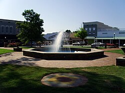
Monticello, Arkansas
| Monticello, Arkansas | |
|---|---|
| City | |
 |
|
 Location in Drew County and the state of Arkansas |
|
| Coordinates: 33°37′38″N 91°47′38″W / 33.62722°N 91.79389°WCoordinates: 33°37′38″N 91°47′38″W / 33.62722°N 91.79389°W | |
| Country | United States |
| State | Arkansas |
| County | Drew |
| Government | |
| • Type | Mayor-council government |
| • Mayor | Zackery Tucker |
| Area | |
| • Total | 11.03 sq mi (28.58 km2) |
| • Land | 11.02 sq mi (28.54 km2) |
| • Water | 0.02 sq mi (0.04 km2) |
| Elevation | 292 ft (89 m) |
| Population (2010) | |
| • Total | 9,467 |
| • Density | 859/sq mi (331.7/km2) |
| Time zone | Central (CST) (UTC-6) |
| • Summer (DST) | CDT (UTC-5) |
| ZIP codes | 71655-71657 |
| Area code(s) | 870 |
| FIPS code | 05-46580 |
| GNIS feature ID | 0052144 |
| Website | www |
Monticello /mɒntɪsɛloʊ/ is a city in and the county seat of Drew County, Arkansas, in the United States. As of the 2010 census it had a population of 9,467.
Founded in 1849 in the Arkansas Timberlands very near the Arkansas Delta region, the city has long been a commercial, cultural and educational hub for southeast Arkansas. With a historically agriculture- and silviculture-based economy, Monticello has diversified to include growth from the medical sector and the University of Arkansas at Monticello.
When Drew County was formed in 1846, its citizens decided that a new town should be built to serve as the county seat. In 1849, land was donated for the town site. The first courthouse was built in 1851, and a second courthouse was erected in 1857.
During the Civil War, several small skirmishes were fought around Monticello. The Rodger's Female Academy was used as a hospital for Confederate soldiers.
Monticello is located west of the center of Drew County at 33°37′38″N 91°47′38″W / 33.62722°N 91.79389°W (33.627183, −91.793787). U.S. Routes 425 and 278 intersect in the city, west of downtown. U.S. 425 leads north 50 miles (80 km) to Pine Bluff and south 29 miles (47 km) to Hamburg, while US 278 leads west 16 miles (26 km) to Warren and east 26 miles (42 km) to McGehee.
...
Wikipedia
