Drew County, Arkansas
| Drew County, Arkansas | |
|---|---|

Drew County Courthouse in Monticello
|
|
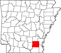
 Location in the U.S. state of Arkansas |
|
 Arkansas's location in the U.S. |
|
| Founded | November 26, 1846 |
| Named for | Thomas Drew |
| Seat | Monticello |
| Largest city | Monticello |
| Area | |
| • Total | 836 sq mi (2,165 km2) |
| • Land | 828 sq mi (2,145 km2) |
| • Water | 7.3 sq mi (19 km2), 0.9% |
| Population (est.) | |
| • (2015) | 18,778 |
| • Density | 22/sq mi (8/km²) |
| Congressional district | 4th |
| Time zone | Central: UTC-6/-5 |
| Website | drewcounty |
Drew County is a county located in the southeast region of the U.S. state of Arkansas. As of the 2010 census, the population was 18,509, making it the thirty-ninth most populous of Arkansas's seventy-five counties. The county seat and largest city is Monticello. Drew County was formed on November 26, 1846, and named for Thomas Drew, the 3rd governor of Arkansas.
Located on the edge of the Arkansas Timberlands and the Arkansas Delta, its fertile soils produced prosperity for early settlers in the antebellum era. Cotton was the major commodity crop, but corn, apples, peaches and tomatoes were also grown. Following the Civil War, the boundaries of Drew County changed.
In the late 19th and early 20th centuries, timber harvesting became an important industry. As a variety of industries began to move to the county, several colleges were founded in the county in the early part of the 20th century, one developing as University of Arkansas at Monticello. Today the county has a diverse economy and is an economic center in southeast Arkansas.
According to the U.S. Census Bureau, the county has a total area of 836 square miles (2,170 km2), of which 828 square miles (2,140 km2) is land and 7.3 square miles (19 km2) (0.9%) is water.
Loggy Bayou is a swamp in Drew County, not to be confused with a bayou of the same name in northwestern Louisiana.
As of the 2000 United States Census, there were 18,723 people, 7,337 households, and 5,091 families residing in the county. The population density was 23 people per square mile (9/km²). There were 8,287 housing units at an average density of 10 per square mile (4/km²). The racial makeup of the county was 70.30% White, 27.16% Black or African American, 0.25% Native American, 0.42% Asian, 0.02% Pacific Islander, 1.00% from other races, and 0.85% from two or more races. 1.76% of the population were Hispanic or Latino of any race.
...
Wikipedia
