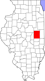
Stanton Township, Champaign County, Illinois
| Stanton Township | |
|---|---|
| Township | |
 Location in Champaign County |
|
 Champaign County's location in Illinois |
|
| Coordinates: 40°11′14″N 88°03′53″W / 40.18722°N 88.06472°WCoordinates: 40°11′14″N 88°03′53″W / 40.18722°N 88.06472°W | |
| Country | United States |
| State | Illinois |
| County | Champaign |
| Area | |
| • Total | 34.76 sq mi (90.0 km2) |
| • Land | 34.71 sq mi (89.9 km2) |
| • Water | 0.06 sq mi (0.2 km2) 0.17% |
| Elevation | 669 ft (204 m) |
| Population (2010) | |
| • Estimate (2016) | 502 |
| • Density | 14.6/sq mi (5.6/km2) |
| Time zone | CST (UTC-6) |
| • Summer (DST) | CDT (UTC-5) |
| FIPS code | 17-019-72273 |
Stanton Township is a township in Champaign County, Illinois, USA. As of the 2010 census, its population was 505 and it contained 202 housing units.
Stanton Township formed from a portion of St. Joseph Township on an unknown date. The first settler in the township was called Samuel McClughen, who came from Ohio in 1834.
According to the 2010 census, the township has a total area of 34.76 square miles (90.0 km2), of which 34.71 square miles (89.9 km2) (or 99.86%) is land and 0.06 square miles (0.16 km2) (or 0.17%) is water. The stream of Spoon River runs through this township.
Cemeteries in Stanton Township include: Huls Cemetery South (also known as Stanton Friends or Friends Church)[1].
(This list is based on USGS data and may include former settlements.)
...
Wikipedia
