Standing Stone Township, Pennsylvania
| Standing Stone Township, Pennsylvania |
|
|---|---|
| Township | |

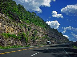
The construction of U.S. Route 6 exposed geologic layers in Standing Stone Township.
|
|
 Map of Bradford County with Standing Stone Township highlighted |
|
 Map of Bradford County, Pennsylvania |
|
| Country | United States |
| State | Pennsylvania |
| County | Bradford |
| Settled | 1774 |
| Incorporated | 1841 |
| Area | |
| • Total | 16.23 sq mi (42.04 km2) |
| • Land | 15.68 sq mi (40.61 km2) |
| • Water | 0.55 sq mi (1.42 km2) |
| Population (2010) | |
| • Total | 642 |
| • Estimate (2016) | 643 |
| • Density | 41.01/sq mi (15.83/km2) |
| FIPS code | 42-015-73632 |
Standing Stone Township is a township in Bradford County, Pennsylvania, United States. The population was 642 at the 2010 census.
Standing Stone Township is located in eastern Bradford County and is bordered by Herrick Township to the north and east and Wyalusing Township to the southeast. The Susquehanna River forms a winding border with Asylum Township to the south and west. Wysox Township is on the northwestern border of the township. U.S. Route 6 passes through the township, leading west to Towanda, the county seat, and southeast to Wyalusing.
According to the United States Census Bureau, the township has a total area of 16.2 square miles (42.0 km2), of which 15.7 square miles (40.6 km2) is land and 0.54 square miles (1.4 km2), or 3.38%, is water.
As of the census of 2000, there were 596 people, 210 households, and 161 families residing in the township. The population density was 37.6 people per square mile (14.5/km²). There were 268 housing units at an average density of 16.9/sq mi (6.5/km²). The racial makeup of the township was 97.99% White, 0.50% African American, 0.67% Native American, 0.17% Asian, and 0.67% from two or more races. Hispanic or Latino of any race were 0.34% of the population.
...
Wikipedia
