Wyalusing Township, Bradford County, Pennsylvania
| Wyalusing Township, Pennsylvania |
|
|---|---|
| Township | |

View from Wyalusing Rocks
|
|
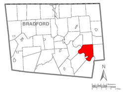
 Map of Bradford County with Wyalusing Township highlighted |
|
 Map of Bradford County, Pennsylvania |
|
| Country | United States |
| State | Pennsylvania |
| County | Bradford |
| Settled | 1773 |
| Incorporated | 1790 |
| Area | |
| • Total | 28.8 sq mi (74.6 km2) |
| • Land | 27.9 sq mi (72.3 km2) |
| • Water | 0.9 sq mi (2.3 km2) |
| Population (2010) | |
| • Total | 1,242 |
| • Density | 45/sq mi (17.2/km2) |
| Area code(s) | 570 |
Wyalusing Township is a township in Bradford County, Pennsylvania, United States. The population was 1,242 at the 2010 census.
The Ellen and Charles F. Welles House was added to the National Register of Historic Places in 1999.
Wyalusing Township is located in southeast Bradford County, along the northeast bank of the Susquehanna River. It is bordered by Standing Stone Township to the northwest, Herrick Township to the north, Stevens Township to the northeast, and Tuscarora Township to the east. Across the Susquehanna River are Wilmot Township to the south, Terry Township to the southwest, and Asylum Township to the west. The borough of Wyalusing lies along the river on the Terry Township border but is separate from Wyalusing Township. The unincorporated community of Camptown is in the northeast part of the township, and Browntown is in the south.
According to the United States Census Bureau, the township has a total area of 28.8 square miles (74.6 km2), of which 27.9 square miles (72.3 km2) is land and 0.89 square miles (2.3 km2), or 3.08%, is water.Wyalusing Creek flows from north to south through the eastern part of the township, into the Susquehanna River.
...
Wikipedia
