Stafford, Sutter County, California
| City of Live Oak | |
|---|---|
| City | |

Live Oak, California. On Live Oak blvd and Pennington Road access to Leo Cheney Correctional Center.
|
|
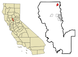
 Location in Sutter County and the state of California |
|
| Location in the United States | |
| Coordinates: 39°16′33″N 121°39′36″W / 39.27583°N 121.66000°WCoordinates: 39°16′33″N 121°39′36″W / 39.27583°N 121.66000°W | |
| Country |
|
| State |
|
| County | Sutter |
| Incorporated | January 22, 1947 |
| Government | |
| • Type | Council-Manager |
| • Mayor | Jason Banks |
| Area | |
| • Total | 1.869 sq mi (4.839 km2) |
| • Land | 1.869 sq mi (4.839 km2) |
| • Water | 0 sq mi (0 km2) 0% |
| Elevation | 79 ft (24 m) |
| Population (2010) | |
| • Total | 8,392 |
| • Estimate (2016) | 8,800 |
| • Density | 4,500/sq mi (1,700/km2) |
| Time zone | Pacific (PST) (UTC-8) |
| • Summer (DST) | PDT (UTC-7) |
| ZIP codes | 95953 |
| Area code(s) | 530 |
| FIPS code | 06-41936 |
| GNIS feature IDs | 277541, 2410846 |
| Website | www |
| U.S. Geological Survey Geographic Names Information System: Live Oak, Sutter County, California | |
Live Oak is an incorporated city in Sutter County, California, United States. It is part of the Yuba City Metropolitan Statistical Area within the Greater Sacramento CSA, and includes a hamlet historically named Stafford. The population was 8,392 at the 2010 census.
Live Oak is located at 39°16′28″N 121°39′43″W / 39.27444°N 121.66194°W (39.274518, -121.662003).
According to the United States Census Bureau, the city has a total area of 2.5 square miles (4.8 km²), all of it land. Live Oak is an agricultural community located in the fertile Sacramento Valley. Rich farmlands, orchards, the Feather River, and the Sutter Buttes surround Live Oak.
Live Oak's climate usually consists of hot, dry summers and prolonging wet, cool winters, a Mediterranean climate. Summers are hot, sunny and dry but a delta breeze occurs at times. This cools the temperature but doesn't last long. Heat waves occur during the summer months, lasting for 3–5 days on average. Temperatures range from 105 to 110 degrees. Dry months range from mid to late May to early to mid September where rainfall is rare. The hottest month is July with temperatures averaging around 96 to 100 degrees with no rain but it isn't rare for some rain to arrive from the Southwest Monsoon. Winters are prolonging wet, cool and foggy. Wet months range from mid October to mid April where rainfall becomes constant. January is the wettest and coolest month with rainfall averaging between 4 and 6 inches but during El Niño season, rainfall averages 10 to 12 inches which causes major flooding. During the La Niña season, rainfall averages 4 inches or below, causing drought problems during summer. In the winter, temperatures average 45 to 50 degrees. Foggy and cloudy weather can last up to 2 to 4 weeks, also known as Tule fog. Snow occurs rarely. The record amount of snow was 3.8 inches in 2002.
...
Wikipedia

