
Stadthagen
| Stadthagen | ||
|---|---|---|

Market square. The photo shows the entrance to the Marktpassage, an indoor shopping arcade.
|
||
|
||

Stadthagen
|
||
|
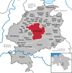
Location of Stadthagen within Schaumburg district
  |
||
| Coordinates: 52°19′29″N 9°12′25″E / 52.32472°N 9.20694°ECoordinates: 52°19′29″N 9°12′25″E / 52.32472°N 9.20694°E | ||
| Country | Germany | |
| State | Lower Saxony | |
| District | Schaumburg | |
| Government | ||
| • Mayor | Oliver Theiß (Ind.) | |
| Area | ||
| • Total | 60.27 km2 (23.27 sq mi) | |
| Elevation | 72 m (236 ft) | |
| Population (2015-12-31) | ||
| • Total | 21,814 | |
| • Density | 360/km2 (940/sq mi) | |
| Time zone | CET/CEST (UTC+1/+2) | |
| Postal codes | 31655 | |
| Dialling codes | 05721 | |
| Vehicle registration | SHG | |
| Website | www.stadthagen.de | |
Stadthagen (German pronunciation: [ʃtatˈhaːɡən]) is the capital of the district of Schaumburg, in Lower Saxony, Germany. It is situated approximately 20 km east of Minden and 40 km west of Hanover. The city consists of the districts Brandenburg, Enzen-Hobbensen, Hörkamp-Langenbruch, Krebshagen, Obernwöhren, Probsthagen, Reinsen and Wendthagen-Ehlen. Earlier, there were also the districts Habichhorst, Bruchhof, Blyinghausen, Enzen and Hobbensen.
Stadthagen is located on the German Timber-Frame Road.
Count Adolf III of Holstein created a new settlement at the foot of the Bückeberg around 1224. Its site near the Hellweg route testifies to his strategic and commercial wisdom. After the successful clearances of the Dülwald forest around 1224, a new settlement by the name of indago comitis (the count's enclosure - the same name as The Hague) was first recorded in 1244 when it was described as a city and fort. In 1287 the town changed its name to Grevenalveshagen (Count Adolf's enclosure) and it finally acquired its current name of Stadthagen in 1378. Further highlights of the town's early history are the acquisition of the town seal in 1320 and the bestowal of the privileges of a town in 1344.
Around 1400 stone fortifications were erected. The surviving remnants of these include the tower at the Cattle Market, a small tower at the Castle, and sections of the town wall.
In 1501 coal mining began nearby, and lasted until 1961.
In 1559 the resident Count Otto IV introduced the Lutheran denomination. His predecessor Count Adolf XI had commissioned the current castle from architect Jörg Unkair of Tübingen. It was built between 1534 and 1538 on the site of the previous castle, and is one of the most notable examples of an Early Renaissance castle in Lower Saxony. The official entrance was built in 1553 at the then Upper Gate. In 1607 Prince Ernst of Schaumburg moved his residence from Stadthagen to Bückeburg. The year 1609 saw the erection of the count's mausoleum at the back of the St Martini church, a domed heptagon with a famous resurrection group by Adriaen de Vries. The grammar school of 1610 was elevated to the status of a university in 1620, although this soon moved to Rinteln.
...
Wikipedia