
Stadland
| Stadland | ||
|---|---|---|
|
||

Stadland
|
||
|
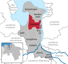
Location of Stadland within Wesermarsch district
  |
||
| Coordinates: 53°23′N 8°23′E / 53.383°N 8.383°ECoordinates: 53°23′N 8°23′E / 53.383°N 8.383°E | ||
| Country | Germany | |
| State | Lower Saxony | |
| District | Wesermarsch | |
| Government | ||
| • Mayor | Boris Schierhold (Ind.) | |
| Area | ||
| • Total | 113.38 km2 (43.78 sq mi) | |
| Elevation | 1 m (3 ft) | |
| Population (2015-12-31) | ||
| • Total | 7,476 | |
| • Density | 66/km2 (170/sq mi) | |
| Time zone | CET/CEST (UTC+1/+2) | |
| Postal codes | 26935, 26936, 26937 | |
| Dialling codes | 04732 (Rodenkirchen), 04737 (Schwei), 04734 (Seefeld), 04731 (Kleinensiel) | |
| Vehicle registration | BRA | |
| Website | www.stadland.de | |

Stadland is a municipality in the district of Wesermarsch, in Lower Saxony, Germany. It is situated on the left bank of the Weser, approx. 32 km northeast of Oldenburg, and 42 km northwest of Bremen. On the west side Stadland bordered to the Jade Bight. Its seat is in the village Rodenkirchen, which is also part of this municipality as the villages Schwei, Seefeld and Kleinensiel. There are also many little Bauernschaften (hamlets) in Stadland.
In 1974 Stadland was built in cause of the Niedersächsische Gemeindereform. The former municipalities Rodenkirchen, Schwei and Seefeld and also Kleinensiel, a part of the former municipality Esenshamm (now: Nordenham) were built up to the new municipality Stadland.
Stadland has a Partnership with the District du Petit Caux (Normandy, France). This partnership is affirmed by mutual attendance of grades and private people in each year.
Tunnel of the Weser River (Kleinensiel)
Friesendenkmal - Monument in Rodenkirchen
Markthalle in Rodenkirchen
Roonkarker Mart, a yearly funfair in Rodenkirchen at the end of September
...
Wikipedia