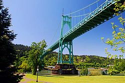
St. Johns, Portland, Oregon
| St. Johns | |
|---|---|
| Neighborhood | |
 |
|
| Coordinates: 45°36′45″N 122°45′46″W / 45.61259°N 122.76287°WCoordinates: 45°36′45″N 122°45′46″W / 45.61259°N 122.76287°W PDF map |
|
| Country | United States |
| State | Oregon |
| City | Portland |
| Government | |
| • Association | St. Johns Neighborhood Association |
| • Coalition | www |
| Area | |
| • Total | 11.02 sq mi (28.55 km2) |
| Population (2000) | |
| • Total | 11,346 |
| • Density | 1,000/sq mi (400/km2) |
| Housing | |
| • No. of households | 4148 |
| • Occupancy rate | 93% occupied |
| • Owner-occupied | 2333 households (56%) |
| • Renting | 1815 households (44%) |
| • Avg. household size | 2.74 persons |
St. Johns is a neighborhood of Portland, Oregon, United States, located in North Portland on the tip of the peninsula formed by the confluence of the Willamette River and the Columbia River. It was a separate, incorporated city from 1902 until 1915, when citizens of both St. Johns and Portland voted to approve its annexation to Portland, which took effect on July 8, 1915.
St. Johns is bordered by the Columbia River (separating it from Hayden Island) to the northeast, the Willamette River (separating it from Sauvie Island and Linnton) to the northwest, the North Portland railroad cut the University Park, Portsmouth, and Cathedral Park, the neighborhood to the southwest. St. Johns sits north of Cathedral Park, which is home to the only suspension bridge in the Willamette Valley, the St. Johns Bridge. The main business district of St. Johns (referred to as "Downtown" or "Deep St. Johns") is around the intersection of Lombard and Philadelphia Streets.
Historian Eva Emery Dye, while looking at the original Lewis and Clark Expedition journals, made the discovery that William Clark made camp at the modern site of Cathedral Park near a Native American settlement for one night.
St. Johns is named in honor of settler James John. He made his journey to the Pacific Northwest from Westport, Missouri in 1841. His first residence was in Linnton, Oregon before moving across the river no earlier than 1844. Five years after John's settlement, nearly 12 families laid claim to land in the vicinity. In 1865, John had a portion of his land surveyed and plotted into eight blocks for a townsite. Additional blocks were added in 1870 and 1876. John would often donate small parcels of his land to his friends without means. After his death, James John left his remaining personal property to the township of St. Johns to use to build a public school. It was John's wish that children of all religious denominations could study together and receive an education that stressed the importance of civic engagement. John requested that all of his assets be sold off to raise funds for first his burial and funeral and the remainder to building the new school house.
...
Wikipedia

