Springlake, Texas
| Springlake, Texas | |
|---|---|
| Town | |

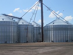
Grain silos in Springlake, Texas
|
|
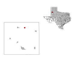
 Location of Springlake, Texas |
|
 |
|
| Coordinates: 34°13′52″N 102°18′17″W / 34.23111°N 102.30472°WCoordinates: 34°13′52″N 102°18′17″W / 34.23111°N 102.30472°W | |
| Country | United States |
| State | Texas |
| County | Lamb |
| Area | |
| • Total | 1.0 sq mi (2.6 km2) |
| • Land | 1.0 sq mi (2.6 km2) |
| • Water | 0.0 sq mi (0.0 km2) |
| Elevation | 3,681 ft (1,122 m) |
| Population (2010) | |
| • Total | 108 |
| • Density | 110/sq mi (42/km2) |
| Time zone | Central (CST) (UTC-6) |
| • Summer (DST) | CDT (UTC-5) |
| ZIP code | 79082 |
| Area code(s) | 806 |
| FIPS code | 48-69764 |
| GNIS feature ID | 1369043 |
Springlake is a town in Lamb County, Texas, United States. The population was 108 at the 2010 census. The community is known for its agricultural processing and its yearly Independence Day parade and celebration culminating in a fantastic fireworks display headed by the Springlake Volunteer Fire Department. This celebration usually draws several thousand participants who come together to enjoy free food, a free live band, a bake auction, and fellowship.
It was the hometown of the late Speaker of the Texas House of Representatives, Bill W. Clayton.
Springlake is located at 34°13′52″N 102°18′17″W / 34.23111°N 102.30472°W (34.231217, -102.304707).
According to the United States Census Bureau, the town has a total area of 1.0 square mile (2.6 km2), all of it land.
As of the census of 2000, there were 135 people, 54 households, and 38 families residing in the town. The population density was 132.6 people per square mile (51.1/km²). There were 68 housing units at an average density of 66.8 per square mile (25.7/km²). The racial makeup of the town was 80.00% White, 0.74% African American, 19.26% from other races. Hispanic or Latino of any race were 33.33% of the population.
...
Wikipedia
