Springboro, OH
| Springboro | |
|---|---|
| City | |
| City of Springboro, Ohio | |

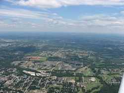
Lower Springboro from the air
|
|
| Motto: "Live. Work. Play. Learn. Grow." | |
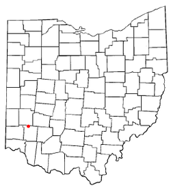
 Location of Springboro, Ohio |
|
 Location of Springboro in Warren County |
|
| Coordinates: 39°33′20″N 84°14′00″W / 39.55556°N 84.23333°WCoordinates: 39°33′20″N 84°14′00″W / 39.55556°N 84.23333°W | |
| Country | United States |
| State | Ohio |
| Counties | Warren, Montgomery |
| Area | |
| • Total | 10.5 sq mi (24.24 km2) |
| • Land | 10.5 sq mi (24.24 km2) |
| • Water | 0 sq mi (0 km2) |
| Elevation | 774 ft (236 m) |
| Population (2010) | |
| • Total | 17,409 |
| • Estimate (2012) | 17,643 |
| • Density | 1,859.9/sq mi (718.1/km2) |
| Time zone | Eastern (EST) (UTC-5) |
| • Summer (DST) | EDT (UTC-4) |
| ZIP code | 45066, 45342 |
| Area code(s) | 937, 513 |
| FIPS code | 39-74076 |
| GNIS feature ID | 1061205 |
| Website | http://www.cityofspringboro.com/ |
Springboro is a city in the U.S. state of Ohio. An affluent suburb of Cincinnati and Dayton, it is located mostly in Warren County in Clearcreek and Franklin Townships; with a small portion in Miami Township in Montgomery County. The city is part of the Miami Valley. As of the 2010 census, the city had a population of 17,409.
Springboro is located at the geographic center of the Cincinnati-Dayton Metroplex, the 14th largest urban area in the United States. Most of the city is located in Warren County, and is part of the Cincinnati–Middletown Metropolitan Statistical Area. The far northern portion is in Montgomery County, the central county of the Dayton Metropolitan Statistical Area. Most of Springboro is served by the Springboro Community School District and its high school, Springboro High School. In 2011, Springboro was ranked the 42nd best place to live in America by Money magazine, and in 2014 Springboro was ranked the 10th best suburb in America by Business Insider.
According to the United States Census Bureau, the city has a total area of 9.36 square miles (24.24 km2), all land.
Springboro is accessible by three of the major expressways in the Cin-Day Metro Region:
The main crossroads of the city center are ![]() SR 73 (Central Avenue) and
SR 73 (Central Avenue) and ![]() SR 741 (Main Street). Central Avenue runs east-west, and Main Street is the north-south thru-way, connecting the city with the urban cores of Cincinnati and Dayton. Main Street is also used as an alternate route to Interstate-75.
SR 741 (Main Street). Central Avenue runs east-west, and Main Street is the north-south thru-way, connecting the city with the urban cores of Cincinnati and Dayton. Main Street is also used as an alternate route to Interstate-75.
...
Wikipedia
