Spring Valley, New York
| Spring Valley, New York | |
|---|---|
| City | |
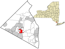
 Location in Rockland County and the state of New York. |
|
| Location within the state of New York | |
| Coordinates: 41°6′52″N 74°2′52″W / 41.11444°N 74.04778°WCoordinates: 41°6′52″N 74°2′52″W / 41.11444°N 74.04778°W | |
| Country | United States |
| State | New York |
| County | Rockland |
| Incorporated | July 9, 1902 |
| Government | |
| • Mayor | Demeza Delhomme (D) |
| Area | |
| • Total | 2.1 sq mi (5.5 km2) |
| • Land | 2.1 sq mi (5.4 km2) |
| • Water | 0.47 sq mi (0 km2) |
| Population (2010) | |
| • Total | 31,347 |
| • Density | 15,000/sq mi (5,700/km2) |
| Time zone | Eastern (EST) (UTC-5) |
| • Summer (DST) | EDT (UTC-4) |
| ZIP code | 10977 |
| Area code(s) | 845 |
| FIPS code | 36-70420 |
| Website | www.villagespringvalley.org |
Spring Valley is a village in the towns of Ramapo and Clarkstown in Rockland County, New York, United States. It is located north of Chestnut Ridge, east of Airmont and Monsey, south of Hillcrest, and west of Nanuet. The population was 31,347 at the 2010 census, making it the 2nd most populous community in Rockland County, after New City.
Spring Valley spans the border of two towns, occupying an eastern portion of the town of Ramapo and a small western portion of the town of Clarkstown. The village is next to the New York State Thruway (Interstate 87) and is served by a New Jersey Transit train station at the terminus of the Pascack Valley Line.
Spring Valley is 22 miles (35 km) north of Manhattan and 5 miles (8 km) north of the New Jersey border.
Before the opening of the railroad, there were no homes in Spring Valley.
In 1842, the New York & Erie Railroad called this part of the territory "Pascack", after a stream by the same name. The residents of the area decided to call the place Spring Valley – one certain large spring in the Valley Pond being responsible for the name. Prior to naming the territory Spring Valley, it was called Scotland, named after their homeland, by Scotsmen who had settled in the area.
...
Wikipedia

