Spijkenisse
| Spijkenisse | |||
|---|---|---|---|
| Town and former municipality | |||

Square in Spijkenisse
|
|||
|
|||
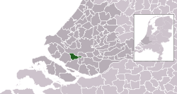
 Location in South Holland |
|||
| Coordinates: 51°51′N 4°20′E / 51.850°N 4.333°ECoordinates: 51°51′N 4°20′E / 51.850°N 4.333°E | |||
| Country | Netherlands | ||
| Province | South Holland | ||
| Municipality | Nissewaard | ||
| Area | |||
| • Total | 30.27 km2 (11.69 sq mi) | ||
| • Land | 26.12 km2 (10.08 sq mi) | ||
| • Water | 4.15 km2 (1.60 sq mi) | ||
| Elevation | −1 m (−3 ft) | ||
| Population (May 2014) | |||
| • Total | 72,545 | ||
| • Density | 2,777/km2 (7,190/sq mi) | ||
| Demonym(s) | Spijkenissenaar | ||
| Time zone | CET (UTC+1) | ||
| • Summer (DST) | CEST (UTC+2) | ||
| Postcode | 3200–3209 | ||
| Area code | 0181 | ||
| Website | www |
||
Spijkenisse (Dutch pronunciation: [spɛi̯kəˈnɪsə]) is a town in the western Netherlands, in the province of South Holland. After an administrative reform in 2015 it is part of the municipality of Nissewaard.
The town has a population of 72,545 in 2014, and covered an area of 30.27 km2 (11.69 sq mi) of which 4.15 km2 (1.60 sq mi) was water. It is part of the Greater Rotterdam Area.
The town also included the communities of Hekelingen, Den Hoek and Beerenplaat.
Archaeological research has shown that the area around Spijkenisse has been inhabited for many thousands of years. The people then depended on fishing on the Meuse and hunting in the swamps.
The oldest reference to the name Spickenisse is from a source from 1231. This name comes from the words spieke (spit) and nesse (nose) meaning "pointy nose" in reference to a spit of land protruding along the river.
Spijkenisse formed as a farmers and fishing village at a creek along the Oude Maas. Initially it belonged to the Lord of Putten (whose coat of arms is now used by the city) but in 1459 the fiefdom Putten, including Spijkenisse, was transferred to Philip III, Duke of Burgundy. In 1581, after the Dutch declaration of independence, the area came under the control of the States of Holland and West Frisia.
In the 16th century the village suffered several floods. In the 17th and 18th centuries it endured destructive fires which hampered its economic growth.
Spijkenisse has a connection to the city of Rotterdam by Rotterdam Metro lines C and D, through Spijkenisse Centrum, Heemraadlaan, and De Akkers stations. The metro is operated by RET.
...
Wikipedia


