Spiesheim
| Spiesheim | ||
|---|---|---|
|
||
| Coordinates: 49°48′37″N 08°07′38″E / 49.81028°N 8.12722°ECoordinates: 49°48′37″N 08°07′38″E / 49.81028°N 8.12722°E | ||
| Country | Germany | |
| State | Rhineland-Palatinate | |
| District | Alzey-Worms | |
| Municipal assoc. | Wörrstadt | |
| Government | ||
| • Mayor | Hans-Philipp Schmitt (SPD) | |
| Area | ||
| • Total | 7.31 km2 (2.82 sq mi) | |
| Population (2015-12-31) | ||
| • Total | 966 | |
| • Density | 130/km2 (340/sq mi) | |
| Time zone | CET/CEST (UTC+1/+2) | |
| Postal codes | 55288 | |
| Dialling codes | 06732 | |
| Vehicle registration | AZ | |
| Website | www.spiesheim.de | |
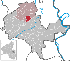
Spiesheim is an Ortsgemeinde – a municipality belonging to a Verbandsgemeinde, a kind of collective municipality – in the Alzey-Worms district in Rhineland-Palatinate, Germany.
As a winegrowing centre, Spiesheim lies in Germany’s biggest winegrowing district, in the middle of the wine region of Rhenish Hesse. It belongs to the Verbandsgemeinde of Wörrstadt, whose seat is in the like-named municipality. The nearest town is Alzey (6 km) and the state capital of Mainz, which is less than 30 km away, can easily be reached over Autobahn A 63. The 750 ha municipal area has a variance in elevation of more than 100 m.
Spiesheim’s neighbours are Albig, Biebelnheim, Ensheim and Wörrstadt.
Documented by archaeology are traces of Celtic settlement from the time beginning in 250 BC. Further finds have established a continuous Roman settlement. In the 5th century came the taking of the land by the Franks, out of which arose the founding of the municipality under the name Spizisheim. In 750, Spiesheim had its first documentary mention in a document that dealt with a donation of vineyards and cropfields to Lorsch Abbey.
The council is made up of 12 council members, who were elected at the municipal election held on 7 June 2009, and the honorary mayor as chairman.
...
Wikipedia


