Speyerbach
| Speyerbach | |
|---|---|

The Speyerbach in the town of Speyer
|
|

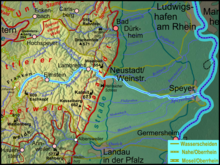
Course of the Speyerbach to the Rhine through the Palatinate Forest and Rhine valley
|
|
| Country | Germany |
| State | Rhineland-Palatinate |
| Basin features | |
| Main source | near Speyerbrunn 296 m (971 ft) 49°20′58.7″N 7°52′13″E / 49.349639°N 7.87028°E |
| River mouth |
Speyer 92 m (302 ft) 49°19′9.5″N 8°26′58″E / 49.319306°N 8.44944°ECoordinates: 49°19′9.5″N 8°26′58″E / 49.319306°N 8.44944°E |
| Progression | Rhine → North Sea |
| River system | Rhine |
| Basin size | 596 km2 (230 sq mi) |
| Tributaries |
|
| Physical characteristics | |
| Length | 60.1 km (37.3 mi) |
| Discharge |
|
| Cities, towns, and municipalities | Town, Speyer, Lambrecht, Elmstein, Esthal, Frankeneck, Hanhofen, Dudenhofen |
The Speyerbach is a left tributary of the Rhine in the Palatinate part of Rhineland-Palatinate. In Speyer, the river split into Gießhübelbach and Woogbach. The Woogbach changes its name to Nonnenbach, then flows into Gießhübelbach shortly before the latter flows into the Rhine.
Although only classified as a river of the third rank under German river classification system, the Speyerbach is the largest river of the Anterior Palatinate. It is 60 kilometres (37 mi) long; its catchment area is 596 square kilometres (230 sq mi); its discharge varies between 1 and 5 cubic metres per second (35 and 177 cu ft/s). In extreme weather conditions with heavy rain in a short time, the discharge may be much higher; the highest peak was 19.5 cubic metres per second (690 cu ft/s) on 25 May 1978.
The nominal source of the Speyerbach is located near the hamlet of Speyerbrunn in the municipality of Elmstein, in the middle of the Palatinate Forest, east of the Palatine Watershed. It has an elevation of 296 metres (971 ft) AMSL; the surrounding Frankenweide hills climbing up to 609 metres (1,998 ft) in height (Eschkopf). Soon after its nominal source, it is joined by the much larger Erlenbach, which rises at the Hussars Fountain, 5 kilometres (3 mi) further south, on the Eschkopf, at an elevation of 460 metres (1,510 ft). So, hydrologically speaking, the Hussars Fountain is the true source of Speyerbach.
From the Speyerbrunn, the Speyerbrunn winds through the narrow Elmstein valley, flowing East at first, then North-East, flowing past the main village of Elmstein. Above the valley, the ruins of four castles are lined in a row. Erfenstein Castle and Spangenberg Castle are well-known from the Legend of the Leather Bridge. About 5 kilometres (3 mi) downstream from Elmstein, the Helmbach flows into the Speyerbach at the hamlet of the same name.
...
Wikipedia
