South Sulawesi
|
South Sulawesi Sulawesi Selatan Sulawesi Maniang ᨔᨘᨒᨓᨙᨔᨗ ᨆᨊᨗᨕ |
|||||||||
|---|---|---|---|---|---|---|---|---|---|
| Province Provinsi |
|||||||||
Clockwise, from top left : Muna Island, Bili-bili Reservoir, Tongkonan houses in Tana Toraja, Limestone hills in Maros, Rice fields in South Sulawesi, Floating houses on Lake Tempe, Tanjung Bira beach
|
|||||||||
|
|||||||||
| Motto: Todo Puli / ᨈᨚᨉᨚᨄᨘᨒᨗ (Keep the faith) |
|||||||||
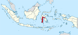
 Location of South Sulawesi in Indonesia |
|||||||||
| Coordinates: 4°20′S 120°15′E / 4.333°S 120.250°ECoordinates: 4°20′S 120°15′E / 4.333°S 120.250°E | |||||||||
| Country |
|
||||||||
| Founded | 19 October 1669 | ||||||||
| Founded As Province | 13 December 1960 | ||||||||
| Capital |
|
||||||||
| Government | |||||||||
| • Body | South Sulawesi Regional Government | ||||||||
| • Governor | Syahrul Yasin Limpo (Golkar) | ||||||||
| • Vice Governor | Agus Arifin Nu'mang | ||||||||
| Area | |||||||||
| • Total | 46,717.48 km2 (18,037.72 sq mi) | ||||||||
| Area rank | 16th | ||||||||
| Highest elevation | 3,478 m (11,411 ft) | ||||||||
| Population (2010) | |||||||||
| • Total | 8,032,551 | ||||||||
| • Density | 170/km2 (450/sq mi) | ||||||||
| Demographics | |||||||||
| • Ethnic groups | Bugis (41.9%), Makassarese (25.43%), Toraja (9.02%), Mandar (6.1%) | ||||||||
| • Religion | Islam (89.62%), Protestantism (7.62%), Roman Catholicism (1.54%), Buddhism (0.24%), Hinduism (0.72%), Confucianism (0.004) | ||||||||
| • Languages | Buginese Makassarese Torajanese (regional) | ||||||||
| Time zone | Central Indonesian Time (UTC+08) | ||||||||
| Postcodes | 90xxx, 91xxx, 92xxx | ||||||||
| Area codes | (62)4xx | ||||||||
| ISO 3166 code | ID-SN | ||||||||
| Vehicle sign | DD, DP, DW | ||||||||
| HDI |
|
||||||||
| HDI rank | 14th (2014) | ||||||||
| Largest city by area | Palopo - 247.52 square kilometres (95.57 sq mi) | ||||||||
| Largest city by population | Makassar - (1,339,374 - 2010) | ||||||||
| Largest regency by area | North Luwu Regency - 7,502.58 square kilometres (2,896.76 sq mi) | ||||||||
| Largest regency by population | Bone Regency - (717,268 - 2010) | ||||||||
| Website | Government official site | ||||||||
South Sulawesi (Indonesian: Sulawesi Selatan) is a province in the southern peninsula of Sulawesi. The Selayar Islands archipelago is also part of the province.
The 2010 census estimated the population as 8,032,551 which makes South Sulawesi the most populous province on the island (46% of the population of Sulawesi is in South Sulawesi), and the sixth most populous province in Indonesia.
South Sulawesi is located at 4°20'S 120°15'E and covers an area of 45,764.53 square kilometres. The province is bordered by Central Sulawesi and West Sulawesi to the north, the Gulf of Bone and Southeast Sulawesi to the east, Makassar Strait to the west, and Flores Sea to the south.
Five years after independence, the government issued Law No. 21 of 1950, which became the basis of the legal establishment for the Sulawesi province. Ten years later, the government passed Law No. 47 of 1960 which endorsed the formation of the South/Southeast Sulawesi province. Four years after that, with Act No. 13 of 1964, the provinces of South Sulawesi and Southeast Sulawesi were separated.
Forty years later, the South Sulawesi government was split into two, with the regencies of Majene, Mamasa, Mamuju, North Mamuju, and Polewali Mandar were separated off into a new West Sulawesi province on 5 October 2004 under Act No. 26 of 2004.
The remaining South Sulawesi Province is divided into 21 regencies and three independent cities, listed below with their (provisional) populations as of the 2010 Census.
...
Wikipedia


