South Shields
| South Shields | |
|---|---|
 View of King Street, which is South Shields' main shopping thoroughfare. The metro station is located above the street, on the bridge. |
|
| South Shields shown within Tyne and Wear | |
| Population | 75,337 |
| OS grid reference | NZ365665 |
| Metropolitan borough | |
| Metropolitan county | |
| Region | |
| Country | England |
| Sovereign state | United Kingdom |
| Post town | SOUTH SHIELDS |
| Postcode district | NE33, NE34 |
| Dialling code | 0191 |
| Police | Northumbria |
| Fire | Tyne and Wear |
| Ambulance | North East |
| EU Parliament | North East England |
| UK Parliament | |

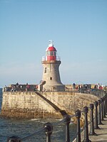
Tyne South Pier lighthouse
|
|
| Location | South Shields |
|---|---|
| Coordinates | 55°00′40″N 1°24′04″W / 55.011208°N 1.400980°W |
| Year first lit | 1895 |
| Construction | stone tower |
| Tower shape | tapered cylindrical tower with balcony and lantern |
| Markings / pattern | ubpainted tower, white half lantern, red half lantern |
| Height | 12 metres (39 ft) |
| Focal height | 15 metres (49 ft) |
| Light source | mains power |
| Range | white: 13 nmi (24 km; 15 mi) red: 9 nmi (17 km; 10 mi) green: 8 nmi (15 km; 9.2 mi) |
| Characteristic | Oc WRG 10s. |
| Fog signal | bell every 10s |
| Admiralty number | A2702 |
| NGA number | 2108 |
| ARLHS number | ENG-158 |
| Managing agent | Port of Tyne |

Herd Groyne lighthouse
|
|
| Location | South Shields |
|---|---|
| Coordinates | 55°00′29″N 1°25′27″W / 55.008021°N 1.424082°W |
| Year first constructed | 1882 |
| Construction | metal skeletal tower |
| Tower shape | hexagonal frustum skeletal tower with observation room, balcony and lantern |
| Markings / pattern | red tower and lantern |
| Height | 15 metres (49 ft) |
| Focal height | 15 metres (49 ft) |
| Light source | mains power |
| Range | white: 19 nmi (35 km; 22 mi) red and green: 11 nmi (20 km; 13 mi) |
| Characteristic | Oc WRG 10s. |
| Fog signal | bell every 5s. |
| Admiralty number | A2702.5 |
| NGA number | 2112 |
| ARLHS number | ENG-330 |
| Managing agent | Port of Tyne |
South Shields is a coastal town at the mouth of the River Tyne, England, about 4.84 miles (7.79 km) downstream from Newcastle upon Tyne. Historically in County Durham, the town has a population of 75,337, the third largest in Tyneside after Newcastle and Gateshead. It is part of the metropolitan borough of South Tyneside which includes the towns of Jarrow and Hebburn. South Shields is represented in Parliament by Labour MP Emma Lewell-Buck. In 2011, South Shields had a population of 75,337.
The first evidence of a settlement within what is now the town of South Shields dates from pre-historic times. Stone Age arrow heads and an Iron Age round house have been discovered on the site of Arbeia Roman Fort. The Roman garrison built a fort here around AD 160 and expanded it around AD 208 to help supply their soldiers along Hadrian's Wall. Divisions living at the fort included Tigris bargemen (from Persia and modern day Iraq), infantry from Iberia and Gaul, and Syrian archers and spearmen. The fort was abandoned as the Roman Empire declined in the 4th century AD. Many ruins still exist today and some structures have been rebuilt as part of a modern museum and popular tourist attraction.
There is evidence that the site was used in the early post-Roman period as a British settlement. It is believed it became a royal residence of King Oswald of Northumbria; records show that his son Oswin was born within 'Caer Urfa', by which name the fort is thought to be known after the Romans left. Furthermore, Bede records Oswin giving a parcel of land to St Hilda for the foundation of a monastery here in c.647; the present-day church of St Hilda, by the Market Place, is said to stand on the monastic site.
...
Wikipedia

