South Scituate
| Norwell, Massachusetts | ||
|---|---|---|
| Town | ||

Jacobs Farmhouse, Norwell Historical Society
|
||
|
||
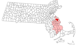
 Location in Plymouth County in Massachusetts |
||
| Coordinates: 42°09′42″N 70°47′40″W / 42.16167°N 70.79444°WCoordinates: 42°09′42″N 70°47′40″W / 42.16167°N 70.79444°W | ||
| Country | United States | |
| State | Massachusetts | |
| County | Plymouth | |
| Settled | 1634 | |
| Incorporated | 1849 | |
| Government | ||
| • Type | Open town meeting | |
| • Town Administrator |
Peter Morin | |
| • Board of Selectmen |
Jason Brown, Chair; Ellen Allen, Vice Chair; Peter Smellie, Clerk; Alison Demong; Gregg McBride | |
| Area | ||
| • Total | 21.2 sq mi (54.8 km2) | |
| • Land | 20.9 sq mi (54.1 km2) | |
| • Water | 0.3 sq mi (0.8 km2) | |
| Elevation | 81 ft (25 m) | |
| Population (2010) | ||
| • Total | 10,506 | |
| • Density | 500/sq mi (190/km2) | |
| Time zone | Eastern (UTC-5) | |
| • Summer (DST) | Eastern (UTC-4) | |
| ZIP code | 02061 | |
| Area code(s) | 339 / 781 | |
| FIPS code | 25-50145 | |
| GNIS feature ID | 0618347 | |
| Website | www |
|
Norwell is a town in Plymouth County, Massachusetts, United States. The population was 10,506 at the 2010 Census. The town's southeastern border runs along the North River.
Norwell was first settled in 1634 as a part of the settlement of Satuit (later Scituate), which encompassed present-day Scituate and Norwell. It was officially created in 1849 and soon became known as South Scituate. The town changed its name by ballot to Norwell in 1888, after Henry Norwell, a dry goods merchant who provided funds for the maintenance of the town roads. Early settlers were attracted to Norwell for agricultural reasons, with the town later developing a major shipbuilding industry, based on the North and Northwest rivers. Shipbuilding was a major industry in the 18th through the early 19th centuries. Some of the finest frigates, schooners, whalers, and merchant vessels were produced in Norwell. The Norwell Village Area Historic District is in the center of the town.
Today, Norwell is an affluent residential community with over 10,000 residents that has modern schools, shopping, churches, libraries, health facilities, a wildlife preserve, and other support facilities as well as three industrial parks.
According to the United States Census Bureau, the town has a total area of 21.2 square miles (55 km2), of which 20.9 square miles (54 km2) is land and 0.3 square miles (0.78 km2), or 1.37%, is water. Some 30% to 38% of the town is wetlands. Located on the South Shore of Massachusetts, Norwell is bordered by Hanover and Rockland on the west, Pembroke on the south, Marshfield and Scituate on the east and northeast, and Hingham on the north. Norwell is about 14 miles (23 km) east of Brockton, 17 miles (27 km) north of Plymouth and 20 miles (32 km) south of Boston.
...
Wikipedia

