South Harrison Township, New Jersey
| South Harrison Township, New Jersey | |
|---|---|
| Township | |
| Township of South Harrison | |
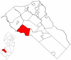
 South Harrison Township highlighted in Gloucester County. Inset map: Gloucester County highlighted in the State of New Jersey. |
|
 Census Bureau map of South Harrison Township, New Jersey |
|
| Coordinates: 39°41′37″N 75°15′14″W / 39.693596°N 75.253779°WCoordinates: 39°41′37″N 75°15′14″W / 39.693596°N 75.253779°W | |
| Country | |
| State |
|
| County |
|
| Incorporated | March 2, 1883 |
| Government | |
| • Type | Township |
| • Body | Township Committee |
| • Mayor | James McCall (R, term ends December 31, 2016) |
| • Clerk | Nancy Kearns |
| Area | |
| • Total | 15.731 sq mi (40.744 km2) |
| • Land | 15.677 sq mi (40.604 km2) |
| • Water | 0.054 sq mi (0.140 km2) 0.34% |
| Area rank | 172nd of 566 in state 11th of 24 in county |
| Elevation | 118 ft (36 m) |
| Population (2010 Census) | |
| • Total | 3,162 |
| • Estimate (2015) | 3,138 |
| • Rank | 446th of 566 in state 19th of 24 in county |
| • Density | 201.7/sq mi (77.9/km2) |
| • Density rank | 505th of 566 in state 24th of 24 in county |
| Time zone | Eastern (EST) (UTC-5) |
| • Summer (DST) | Eastern (EDT) (UTC-4) |
| ZIP code | 08039 - Harrisonville |
| Area code(s) | 856 |
| FIPS code | 3401569030 |
| GNIS feature ID | 0882145 |
| Website | www |
South Harrison Township is a township in Gloucester County, New Jersey, United States. As of the 2010 United States Census, the township's population was 3,162, reflecting an increase of 745 (+30.8%) from the 2,417 counted in the 2000 Census, which had in turn increased by 498 (+26.0%) from the 1,919 counted in the 1990 Census.
South Harrison was formed as a township by an act of the New Jersey Legislature on March 2, 1883, from portions of Harrison Township. Elk Township was formed from portions of South Harrison Township on April 17, 1891. It is a dry town, where alcohol cannot be sold, though alcohol is available at the winery in the township.
According to the United States Census Bureau, the township had a total area of 15.731 square miles (40.744 km2), including 15.677 square miles (40.604 km2) of land and 0.054 square miles (0.140 km2) of water (0.34%).
Unincorporated communities, localities and place names located partially or completely within the township include Cedar Grove, Harrisonville (served as ZIP code 08039), Jessups Mills and Lincoln.
The township borders Woolwich Township, Harrison Township, Elk Township, and Salem County.
...
Wikipedia
