Harrison Township, New Jersey
| Harrison Township, New Jersey | |
|---|---|
| Township | |
| Township of Harrison | |

|
|
 Harrison Township highlighted in Gloucester County. Inset map: Gloucester County highlighted in the State of New Jersey. |
|
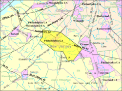
 Census Bureau map of Harrison Township, New Jersey |
|
| Coordinates: 39°43′34″N 75°12′18″W / 39.72601°N 75.20505°WCoordinates: 39°43′34″N 75°12′18″W / 39.72601°N 75.20505°W | |
| Country | |
| State |
|
| County |
|
| Incorporated | March 13, 1844 as Spicer Township |
| Renamed | April 1, 1845 as Harrison Township |
| Named for | William Henry Harrison |
| Government | |
| • Type | Township |
| • Body | Township Committee |
| • Mayor | Louis Manzo (R, term ends December 31, 2018) |
| • Administrator | Mark L. Gravinese |
| • Clerk | Diane Malloy |
| Area | |
| • Total | 19.228 sq mi (49.798 km2) |
| • Land | 19.141 sq mi (49.574 km2) |
| • Water | 0.087 sq mi (0.224 km2) 0.45% |
| Area rank | 146th of 566 in state 7th of 24 in county |
| Elevation | 46 ft (14 m) |
| Population (2010 Census) | |
| • Total | 12,417 |
| • Estimate (2015) | 12,984 |
| • Rank | 195th of 566 in state 8th of 24 in county |
| • Density | 648.7/sq mi (250.5/km2) |
| • Density rank | 420th of 566 in state 18th of 24 in county |
| Time zone | Eastern (EST) (UTC-5) |
| • Summer (DST) | Eastern (EDT) (UTC-4) |
| ZIP code | 08062 - Mullica Hill |
| Area code(s) | 856 |
| FIPS code | 3401530180 |
| GNIS feature ID | 0882146 |
| Website | www |
Harrison Township is a township in Gloucester County, New Jersey, United States. As of the 2010 United States Census, the township's population was 12,417, reflecting an increase of 3,629 (+41.3%) from the 8,788 counted in the 2000 Census, which had in turn increased by 4,073 (+86.4%) from the 4,715 counted in the 1990 Census.
Harrison Township was originally formed as Spicer Township by an act of the New Jersey Legislature on March 13, 1844, from portions of Greenwich Township and Woolwich Township. That name lasted for less than a year, with Harrison Township adopted as of April 1, 1845. The township was named for President William Henry Harrison.
Harrison is a dry township where alcohol cannot be sold.
According to the United States Census Bureau, the township had a total area of 19.228 square miles (49.798 km2), including 19.141 square miles (49.574 km2) of land and 0.087 square miles (0.224 km2) of water (0.45%).
Mullica Hill is an unincorporated community and census-designated place (CDP) located within Harrison Township that had a 2010 Census population of 3,982.Richwood is a CDP that is in portions of both Harrison Township and Mantua Township, which had a 2010 population of 3,459, of which 3,400 were in Harrison Township and 59 in Mantua Township.
Other unincorporated communities, localities and place names located partially or completely within the township include Ewan, Ewans Mills, Heritage, Jefferson and Sherwin.
...
Wikipedia
