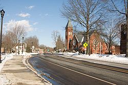
South Hadley, Massachusetts
| South Hadley, Massachusetts | ||
|---|---|---|
| Town | ||
 |
||
|
||
 Location in Hampshire County in Massachusetts |
||
| Coordinates: 42°15′30″N 72°34′30″W / 42.25833°N 72.57500°WCoordinates: 42°15′30″N 72°34′30″W / 42.25833°N 72.57500°W | ||
| Country | United States | |
| State | Massachusetts | |
| County | Hampshire | |
| Settled | 1721 | |
| Incorporated | 1775 | |
| Government | ||
| • Type | Representative town meeting | |
| • Town Administrator | Michael Sullivan | |
| Area | ||
| • Total | 18.4 sq mi (47.6 km2) | |
| • Land | 17.7 sq mi (45.9 km2) | |
| • Water | 0.7 sq mi (1.8 km2) | |
| Elevation | 257 ft (78 m) | |
| Population (2010) | ||
| • Total | 17,514 | |
| • Density | 989.5/sq mi (381.6/km2) | |
| Time zone | Eastern (UTC-5) | |
| • Summer (DST) | Eastern (UTC-4) | |
| ZIP code | 01075 | |
| Area code(s) | 413 | |
| FIPS code | 25-64145 | |
| GNIS feature ID | 0618208 | |
| Website | www.southhadley.org | |
South Hadley (![]() i/ˈhædliː/, HAD-lee) is a town in Hampshire County, Massachusetts, United States. The population was 17,514 at the 2010 census. It is part of the Springfield, Massachusetts Metropolitan Statistical Area.
i/ˈhædliː/, HAD-lee) is a town in Hampshire County, Massachusetts, United States. The population was 17,514 at the 2010 census. It is part of the Springfield, Massachusetts Metropolitan Statistical Area.
South Hadley is home to Mount Holyoke College, South Hadley High School, Pioneer Valley Performing Arts Charter Public School, and the Berkshire Hills Music Academy.
South Hadley was an uninhabited area of Hadley from 1659 until 1721 when the first English settlers arrived from Hadley. A separate town meeting was held in 1753, and the town was officially split and incorporated in 1775.
The town is the home of the nation's first successful navigable canal as well as the oldest continuing institution of higher education for women.
...
Wikipedia

