Souday
| Souday | ||
|---|---|---|
| Commune | ||

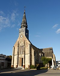
The church of Saint-Pierre, in Souday
|
||
|
||
| Coordinates: 48°02′15″N 0°52′02″E / 48.0375°N 0.8672°ECoordinates: 48°02′15″N 0°52′02″E / 48.0375°N 0.8672°E | ||
| Country | France | |
| Region | Centre-Val de Loire | |
| Department | Loir-et-Cher | |
| Arrondissement | Vendôme | |
| Canton | Le Perche | |
| Intercommunality | Communauté de communes des Collines du Perche | |
| Government | ||
| • Mayor (2008–2014) | Roland Pasquier | |
| Area1 | 36.42 km2 (14.06 sq mi) | |
| Population (2011)2 | 538 | |
| • Density | 15/km2 (38/sq mi) | |
| Time zone | CET (UTC+1) | |
| • Summer (DST) | CEST (UTC+2) | |
| INSEE/Postal code | 41248 /41170 | |
| Elevation | 106–182 m (348–597 ft) (avg. 165 m or 541 ft) |
|
|
1 French Land Register data, which excludes lakes, ponds, glaciers > 1 km² (0.386 sq mi or 247 acres) and river estuaries. 2Population without double counting: residents of multiple communes (e.g., students and military personnel) only counted once. |
||
1 French Land Register data, which excludes lakes, ponds, glaciers > 1 km² (0.386 sq mi or 247 acres) and river estuaries.
Souday is a commune in the Loir-et-Cher department in central France.
Souday, a commune of the Loir-et-Cher in central France, is situated 84 kilometres south west of Paris and only 45 minutes by TGV train from nearby Vendôme. At 165 metres altitude, the village of Souday is built on a chalk plateau which is overlain by a sandy flint clay supporting profitable mixed agriculture. The average rainfall is 800 mm annually, with temperatures ranging from -18 to +42 degrees C.
Extensive deciduous forest, pastures and roadside verges support a wide range of flora and fauna including wild pigs and deer. Spring is heralded by carpets of wild snowdrops followed in quick succession by bluebells, cowslips and wild orchids in the wooded valleys of the rivers Braye, Couetron and Grenne.
The earliest houses in the village are timber framed, followed by flint construction and later with locally made bricks. The church of St Pierre dates back to the 9th century and the two chateaux outside the village date from the 15th and 19th centuries.
The population was 563 at the last census, 465 of whom are over 18 years of age. The small village primary school accommodates 75 children, some of whom come by bus from outlying villages and farms.
Facilities in the village include a restaurant, petrol station and bar, a main dealer garage, unisex hairdresser, grocery shop/post office, bakers and butchers. There is a campsite for tents and caravans with a shower block and electricity points. Outdoor activities include fishing, good walking on marked routes and cycling on quiet roads. There is a pony club, several football teams serving all ages, a village band and a hunting club.
...
Wikipedia


