Soudan mine
|
Soudan Iron Mine
|
|

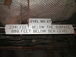
The 27th level of the Soudan Mine
|
|
| Location | Tower-Soudan State Park, Breitung Township, St. Louis County, Minnesota |
|---|---|
| Nearest city | Tower, Minnesota |
| Coordinates | 47°49′24″N 92°14′14″W / 47.82333°N 92.23722°WCoordinates: 47°49′24″N 92°14′14″W / 47.82333°N 92.23722°W |
| Area | 301 acres (122 ha) |
| Built | 1900 |
| Website | Lake Vermilion-Soudan Underground Mine State Park |
| NRHP Reference # | 66000905 |
| Significant dates | |
| Added to NRHP | November 13, 1966 |
| Designated NHL | November 13, 1966 |
The Soudan Underground Mine State Park is a Minnesota state park at the site of the Soudan Underground Mine, on the south shore of Lake Vermilion, in the Vermilion Range (Minnesota). The mine is known as Minnesota's oldest, deepest, and richest iron mine, and now hosts the Soudan Underground Laboratory. As the Soudan Iron Mine, it has been designated a U.S. National Historic Landmark.
In the late 19th century, prospectors searching for gold in northern Minnesota discovered extremely rich veins of hematite at this site, often containing more than 65% iron. An open pit mine began operation in 1882, and moved to underground mining by 1900 for safety reasons. From 1901 until the end of active mining in 1962, the Soudan Mine was owned by the United States Steel Corporation's Oliver Iron Mining division. By 1912 the mine was at a depth of 1,250 feet (381 m). When the mine closed, level 27 was being developed at 2,341 feet (713.5 m) below the surface and the entire underground workings consisted of more than fifty miles of drifts, adits, and raises. In 1965, US Steel donated the Soudan Mine to the State of Minnesota to use for educational purposes.
The primary underground mining method used was known as cut and fill. This involved mining the ceiling and using Ely Greenstone and other waste rock to artificially raise the floor at the same rate as the ceiling was being mined out. As a result, the floor and ceiling were always 10–20 feet (3–6 m) apart, and waste rock never had to be hauled to the surface, since it was recycled. This technique was particularly suited to the Soudan Mine due to the strength of the hematite formations and the weakness of the encasing Greenstone. This method was not possible in the nearby mines in Ely because the iron formations there were fractured and thus were not as structurally stable as those at Soudan.
The park is in Breitung Township, on the shore of Lake Vermilion in northern Minnesota's Vermilion Range. It has become a popular tourist site, often visited on the way to and from Ely and the Boundary Waters Canoe Area Wilderness.
...
Wikipedia


