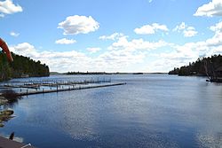
Lake Vermilion
| Lake Vermilion | |
|---|---|

Lake Vermilion during the day
|
|
| Location |
Saint Louis County, Minnesota, United States |
| Coordinates | 47°51′28.47″N 92°17′58.60″W / 47.8579083°N 92.2996111°WCoordinates: 47°51′28.47″N 92°17′58.60″W / 47.8579083°N 92.2996111°W |
| Primary outflows | Vermilion River |
| Basin countries | United States |
| Max. length | 35 mi (56 km) |
| Max. width | 24 mi (39 km) |
| Surface area | 39,271 acres (158.9 km2) |
| Average depth | 25 ft (7.6 m) |
| Max. depth | 76 ft (23 m) |
| Shore length1 | 313 mi (504 km) |
| Surface elevation | 1,358 ft (414 m) |
| Islands | 365 |
| Settlements | Tower and Cook |
| 1 Shore length is not a well-defined measure. | |
Lake Vermilion is a freshwater lake in northeastern Minnesota, United States. The Ojibwe originally called the lake Nee-Man-Nee, which means “the evening sun tinting the water a reddish color”. French fur traders translated this to the Latin word Vermilion, which is a red pigment. Lake Vermilion is located between the towns of Tower on the east and Cook on the west, in the heart of Minnesota's Arrowhead Region at Vermilion Iron Range. The area was mined from the late 19th century until the 1960s, and the Soudan Mine operated just south of the lake.
The lake contains black crappie, bluegill, brown bullhead, largemouth bass, muskellunge, northern pike, sunfish, rock bass, smallmouth bass, tullibee (cisco), walleye, white sucker, and yellow perch. Lake Vermilion is known for its walleye and muskie fishing. In the spring of 2005, Lake Vermilion was host to the annual Minnesota Governor’s Fishing Opener Weekend. Some fish consumption guideline restrictions have been placed on the lake's bluegill, cisco, crappie, northern pike, walleye, and white sucker due to mercury contamination. Many feel the increased population of muskies has had a detrimental effect on the walleye population, although walleye fishing has improved since the implementation of a walleye slot limit (18" to 26") and reduced bag limit (from 6 to 4) in recent years.
...
Wikipedia
