Boundary Waters Canoe Area Wilderness
| Boundary Waters Canoe Area Wilderness | |
|---|---|
|
IUCN category Ib (wilderness area)
|
|

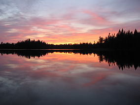
Sunset over Pose Lake, a small lake accessible only by foot.
|
|
| Location | Cook / Lake / Saint Louis counties, Minnesota, United States |
| Coordinates | 48°N 91°W / 48°N 91°WCoordinates: 48°N 91°W / 48°N 91°W |
| Area | 1,090,000 acres (4,400 km2) |
| Established | 1964 |
| Visitors | 250,000+ |
| Governing body | U.S. Forest Service |
The Boundary Waters Canoe Area Wilderness (BWCAW or BWCA), is a 1,090,000-acre (4,400 km2) wilderness area within the Superior National Forest in northeastern Minnesota (United States) under the administration of the U.S. Forest Service. A mixture of north woods forests and glacial lakes and streams, the BWCAW's preservation as a primitive wilderness began in the 1900s and culminated in the Boundary Waters Canoe Area Wilderness Act of 1978. It is a popular destination for both canoeing and fishing on its many lakes and is one of the most visited wildernesses in the United States.
The BWCAW extends along 150 miles (240 km) of the U.S.–Canada border in the Arrowhead Region of Minnesota. The combined region of the BWCAW, Superior National Forest, Voyageurs National Park and Ontario's Quetico and La Verendrye Provincial Parks make up a large area of contiguous wilderness lakes and forests called the "Quetico-Superior country", or simply the Boundary Waters. Lake Superior lies to the south and east of the Boundary Waters.
190,000 acres (770 km2), nearly 20% of the BWCAW's total area is water. Within the borders of the area are over 1,100 lakes and hundreds of miles of rivers and streams. Much of the other 80% of the area is forest. The BWCAW is the largest remaining area of uncut forest in the eastern portion of the United States.
The Laurentian Divide between the Great Lakes and Hudson Bay watersheds runs northeast–southwest through the east side of the BWCAW, following the crest of the Superior Upland and Gunflint Range. The crossing of the divide at Height of Land Portage was an occasion for ceremony and initiation rites for the fur-trading Voyageurs of the 18th and early 19th centuries. The wilderness also includes the highest peak in Minnesota, Eagle Mountain (2,301 feet (701 m)), part of the Misquah Hills.
...
Wikipedia

