Sonoran
| Sonoran Desert | |
| Desert | |
| Countries | United States, Mexico |
|---|---|
| States | Arizona, California, Sonora, Sinaloa, Baja California |
| Part of | North American Desert ecoregion |
| Borders on | Mojave Desert (north) Colorado Plateau (north and east) Peninsular Ranges (west) |
| Lowest point | |
| - location | Salton Sea (below sea level) |
| - elevation | −226 ft (−69 m) |
| Biome | Deserts and xeric shrublands |
| Plant | Madrean Floristic Region |
|
Sonoran Desert
|
|
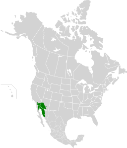
The Sonoran Desert is a North American desert which covers large parts of the Southwestern United States in Arizona and California and of Northwestern Mexico in Sonora, Baja California, and Baja California Sur. It is the hottest desert in Mexico. It has an area of 260,000 square kilometers (100,000 sq mi). The western portion of the United States–Mexico border passes through the Sonoran Desert.
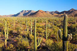
In phytogeography, the Sonoran Desert is within the Sonoran Floristic Province of the Madrean Region in southwestern North America, part of the Holarctic Kingdom of the northern Western Hemisphere. The desert contains a variety of unique and endemic plants and animals, such as the saguaro (Carnegiea gigantea) and organ pipe cactus (Stenocereus thurberi).
The Sonoran desert wraps around the northern end of the Gulf of California, from Baja California Sur (El Vizcaíno Biosphere Reserve in central and Pacific west coast, Central Gulf Coast subregion on east to southern tip), north through much of Baja California, excluding the central northwest mountains and Pacific west coast, through southeastern California and southwestern and southern Arizona to western and central parts of Sonora.
...
Wikipedia


