Somerset Island (Nunavut)

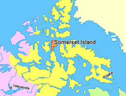
Somerset Island, Nunavut, Canada.
|
|
| Geography | |
|---|---|
| Location | Northern Canada |
| Coordinates | 73°15′N 93°30′W / 73.250°N 93.500°WCoordinates: 73°15′N 93°30′W / 73.250°N 93.500°W |
| Archipelago | Canadian Arctic Archipelago |
| Area | 24,786 km2 (9,570 sq mi) |
| Area rank | 46th |
| Highest elevation | 489 m (1,604 ft) |
| Highest point | Creswell Peak |
| Administration | |
|
Canada
|
|
| Territory | Nunavut |
| Region | Qikiqtaaluk |
| Demographics | |
| Population | Uninhabited |
In the Canadian Arctic Archipelago, Somerset Island is a large, uninhabited island separated by the 2 km wide Bellot Strait from the Boothia Peninsula in the Qikiqtaaluk Region of Nunavut, Canada, lying between Peel Sound (across which lies Prince of Wales Island) and Prince Regent Inlet (across which lies Baffin Island). It has an area of 9,570 square miles (24,800 km2), making it the 46th largest island in the world and Canada's twelfth largest island.
Around 1000 AD, the north coast of Somerset Island was inhabited by the Thule people, as evidenced by whale bones, tunnels and stone ruins.
William Edward Parry was the first European to sight the island in 1819. In late 1848, James Clark Ross, commanding two ships, landed at Port Leopold on the northeast coast to winter. In April the following year, he launched an exploration of the island by sledge.
Roald Amundsen transited the passage between the Island and the Prince of Wales Island in the Gjøa in the first successful traverse of the Northwest Passage in 1904. Henry Larsen transited the passage, in the St Roch in the second successful transit in 1943. But he found this route was dangerously icebound, and also too shallow for commercial travel.
...
Wikipedia

