Solnechny District
| Solnechny District Солнечный район (Russian) |
|
|---|---|
 Location of Solnechny District in Khabarovsk Krai. |
|
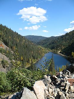
 Amut lake, Solnechny District |
|
|
|
|
| Location | |
| Country | Russia |
| Federal subject | Khabarovsk Krai |
| Administrative structure (as of September 2012) | |
| Administrative center | work settlement of Solnechny |
| Inhabited localities: | |
| Urban-type settlements | 2 |
| Rural localities | 17 |
| Municipal structure (as of October 2010) | |
| Municipally incorporated as | Solnechny Municipal District |
| Municipal divisions: | |
| Urban settlements | 2 |
| Rural settlements | 9 |
| Statistics | |
| Area | 31,085 km2 (12,002 sq mi) |
| Population (2010 Census) | 33,701 inhabitants |
| • Urban | 44.0% |
| • Rural | 56.0% |
| Density | 1.08/km2 (2.8/sq mi) |
| Time zone | VLAT (UTC+10:00) |
| Official website | |
| on | |
Solnechny District (Russian: Со́лнечный райо́н) is an administrative and municipal district (raion), one of the seventeen in Khabarovsk Krai, Russia. It is located in the center of the krai. The area of the district is 31,085 square kilometers (12,002 sq mi). Its administrative center is the urban locality (a work settlement) of Solnechny. Population: 33,701 (2010 Census);36,006 (2002 Census);46,772 (1989 Census). The population of the administrative center accounts for 39.5% of the district's total population.
The district owes its origins to tin exploration and mining and the subsequent Solnechny Processing Complex which sourced its ore from Solnechnoye, Festivalnoye and Predorozhnoye Tin deposits. Currently, the only operating mine is the Festivalnoye mine, operated by Rusolovo. A further operation is based upon the reprocessing of the Predorozhnoye tailings. The Sable (Sobolinoye) tin deposit is currently being developed by Zabaikalskaya Gornorudnaya Kompaniya which uses an English trading name of Sable Tin Resources.
Coordinates: 50°43′N 136°38′E / 50.717°N 136.633°E
...
Wikipedia


