Sobrado, Galicia
| Sobrado | |||
|---|---|---|---|

4046195-1- mosteiro.jpg
|
|||
|
|||
| Coordinates: 43°01′21″N 8°00′52″W / 43.0224°N 8.0144°WCoordinates: 43°01′21″N 8°00′52″W / 43.0224°N 8.0144°W | |||
| Country |
|
||
| Autonomous Community |
|
||
| Province | A Coruña | ||
| Comarca | Terra de Melide | ||
| Government | |||
| • Type | Concello | ||
| • Mayor | Xacobo Fernandez (PP) | ||
| Area | |||
| • Total | 120.64 km2 (46.58 sq mi) | ||
| Elevation | 510 m (1,670 ft) | ||
| Population (2009)INE | |||
| • Total | 2,168 | ||
| • Density | 17.97/km2 (46.5/sq mi) | ||
| Demonym(s) | Sobradense (m),Sobradesa (f) | ||
| Time zone | CET (GMT +1) | ||
| • Summer (DST) | CEST (GMT +2) (UTC) | ||
| Postcode | 15813 | ||
| Area code(s) | +34 | ||
| ISO 3166-2 | ES-C | ||
| Website | http://www.sobrado.es | ||
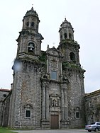
Sobrado is a municipality in the Spanish province of A Coruña located in the northwest of Spain in the autonomous community of Galicia. It has a population of 2,087 (Spanish 2011 Census) and an area of 121 km². Sobrado is well known because of Sobrado Abbey, a Trappist monastery. The town is known by the name Sobrado dos Monxes in Galician or Sobrado de los Monjes in Spanish but the official name is just Sobrado.
The town of Sobrado, in its climatic characteristics (temperatures, precipitation, humidity, hours of direct sunlight) has a climate characteristic of the European Atlantic that means wet and cool, with heavy rainfall due to greater latitude within the autonomous region and the dorsal Galician screen acting for the Atlantic storms that discharge heavy rains on this side, approaching the annual average 1,400 mm.
Temperatures are a little more extreme, the result of the recession of the coastline and its position in the mountains and foothills. The average annual temperature is 8.4 °C, undergoes major changes, with highs in July to 33 °C and minimum in December to 3 °C below zero.
The vast majority of the municipal territory is devoted to forest plantations while the rest goes to the crop. The cultivated areas are devoted mainly to livestock related products, and overflowing the meadows and corn. The gardening plots are reduced to around homes and in a zone where the greenhouses are beginning to abound.
From the physical standpoint, the municipality is located in a mountain area corresponding to the Dorsal Gallega. To the east and the south are the high points of the municipality,the Cova da Serpe mountains and hills do Corno do Boi in the east, and mountains do Bocelo in the south, where we find Megalitics rest like the dolmen of Forno dos Mouros and the "Pena da Moura" two round big rocks where are doubts and legends if was the men who put the rocks there . These mountain systems are around 750 m altitude. They can locate Mount Campelo with 806 m and the mountain of Pilar with 801 m situated at the border of the province, and establishing superb views over the territory.
...
Wikipedia


