Sliedrecht
| Sliedrecht | |||
|---|---|---|---|
| Municipality | |||

Former city hall of Sliedrecht
|
|||
|
|||
 Location in South Holland |
|||
| Coordinates: 51°49′N 4°46′E / 51.817°N 4.767°ECoordinates: 51°49′N 4°46′E / 51.817°N 4.767°E | |||
| Country | Netherlands | ||
| Province | South Holland | ||
| Government | |||
| • Body | Municipal council | ||
| • Mayor | Bram van Hemmen (CDA) | ||
| Area | |||
| • Total | 14.01 km2 (5.41 sq mi) | ||
| • Land | 12.83 km2 (4.95 sq mi) | ||
| • Water | 1.18 km2 (0.46 sq mi) | ||
| Elevation | 4 m (13 ft) | ||
| Population (May 2014) | |||
| • Total | 24,592 | ||
| • Density | 1,917/km2 (4,970/sq mi) | ||
| Demonym(s) | Sliedrechter | ||
| Time zone | CET (UTC+1) | ||
| • Summer (DST) | CEST (UTC+2) | ||
| Postcode | 3360–3364 | ||
| Area code | 0184 | ||
| Website | www |
||
Sliedrecht ![]() listen (population: 24,592 in 2014) is a town and municipality in the western Netherlands, in the province of South Holland. The municipality covers an area of 14.01 km2 (5.41 sq mi) of which 1.18 km2 (0.46 sq mi) is covered by water.
listen (population: 24,592 in 2014) is a town and municipality in the western Netherlands, in the province of South Holland. The municipality covers an area of 14.01 km2 (5.41 sq mi) of which 1.18 km2 (0.46 sq mi) is covered by water.
The first IKEA store in the Netherlands opened in Sliedrecht in 1978, but it closed in 2006. Sliedrecht is also the site of the Nationaal Baggermuseum (National Dredging Museum) - featuring dredging and salvage.
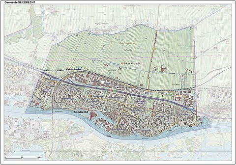
Dutch topographic map of the municipality of Sliedrecht, June 2015
Sliedrecht railway station and Sliedrecht Baanhoek railway station are situated on the Elst–Dordrecht railway.
Waterbus route 2:
...
Wikipedia


