Slavsky District
| Slavsky District Славский район (Russian) |
|
|---|---|
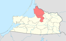
 Location of Slavsky District in Kaliningrad Oblast |
|
| Coordinates: 55°03′N 21°40′E / 55.050°N 21.667°ECoordinates: 55°03′N 21°40′E / 55.050°N 21.667°E | |
 Landscape in Slavsky District |
|
|
|
|
| Location | |
| Country | Russia |
| Federal subject | Kaliningrad Oblast |
| Administrative structure (as of November 2011) | |
| Administrative center | town of Slavsk |
| Administrative divisions: | |
| Towns of district significance | 1 |
| Rural okrugs | 3 |
| Inhabited localities: | |
| Cities/towns | 1 |
| Rural localities | 57 |
| Municipal structure (as of June 2012) | |
| Municipally incorporated as | Slavsky Municipal District |
| Municipal divisions: | |
| Urban settlements | 1 |
| Rural settlements | 3 |
| Statistics | |
| Area | 1,349 km2 (521 sq mi) |
| Population (2010 Census) | 21,015 inhabitants |
| • Urban | 22.0% |
| • Rural | 78.0% |
| Density | 15.58/km2 (40.4/sq mi) |
| Time zone | USZ1 (UTC+02:00) |
| Official website | |
|
[[:commons:Category:
Failed to render property Commons category: Property not found for label 'Commons category' and language 'en' |Slavsky District]] on |
|
Failed to render property Commons category: Property not found for label 'Commons category' and language 'en'
Slavsky District (Russian: Сла́вский райо́н) is an administrative district (raion), one of the fifteen in Kaliningrad Oblast, Russia. As a municipal division, it is incorporated as Slavsky Municipal District. It is located in the northern and central parts of the oblast. The area of the district is 1,349 square kilometers (521 sq mi). Its administrative center is the town of Slavsk. Population: 21,015 (2010 Census); 21,918 (2002 Census);20,864 (1989 Census). The population of Slavsk accounts for 22.0% of the district's total population.
...
Wikipedia

