Skoen
| Medelpad | ||
|---|---|---|
|
||
 |
||
| Country |
|
|
| Land | Norrland | |
| Counties | Västernorrland County | |
| Area | ||
| • Total | 7,058 km2 (2,725 sq mi) | |
| Population (2016) | ||
| • Total | 125,812 | |
| • Density | 18/km2 (46/sq mi) | |
| Ethnicity | ||
| • Language | Swedish (North Swedish) | |
| Culture | ||
| • Flower | Spruce | |
| • Animal | Mountain hare | |
| • Bird | Small crossbill | |
| • Fish | Perch | |
| Time zone | CET (UTC+1) | |
| • Summer (DST) | CEST (UTC+2) | |
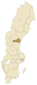
Medelpad (![]() Listen ) is a historical province or landskap in the north of Sweden. It borders Hälsingland, Härjedalen, Jämtland, Ångermanland and the Gulf of Bothnia.
Listen ) is a historical province or landskap in the north of Sweden. It borders Hälsingland, Härjedalen, Jämtland, Ångermanland and the Gulf of Bothnia.
The province is a part of Norrland and as such considered to be Northern Sweden, although the province geographically is located in the middle of Sweden. It is a common misconception that the name "Medelpad" ("middle land" or "middle ground") reflects this, but the name actually refers to the fact that most of the province lies between its two rivers Ljungan and Indalsälven.
The traditional provinces of Sweden serve no administrative or political purposes, but are historical and cultural entities. In the case of Medelpad the province roughly comprises the southern part of the administrative county, län, Västernorrland County.
The arms of Medelpad symbolises the land between the two rivers Ljungan and Indalsälven. As with other Swedish provinces the arms can be represented showing a dukal coronet. Blazon: "Four times parted per fess wavy, Azure, Argent, Gules, Argent and Azure."
The province is situated at an average altitude of 200–300 meters above sea level. The highest mountains are no more than 500 meters high—the tallest is Myckelmyrberget with 577 meters. Of the total area, circa 500 km² is water. The largest lake is Holmsjön, located at 200 meters elevation, followed by Leringen, at a similar elevation.
...
Wikipedia

