Sir Abu Nu'ayr
| Arabic: صير بو نعير | |
|---|---|

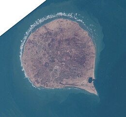
ISS image
|
|
| Sir Abu Nu’ayr (United Arab Emirates) | |
| Geography | |
| Location | Persian Gulf |
| Coordinates | 25°13′54″N 54°13′20″E / 25.23167°N 54.22222°ECoordinates: 25°13′54″N 54°13′20″E / 25.23167°N 54.22222°E |
| Area | 13 km2 (5.0 sq mi) |
| Length | 4.25 km (2.641 mi) |
| Width | 4 km (2.5 mi) |
| Highest elevation | 81 m (266 ft) |
| Administration | |
| Emirate | Sharjah |
Sir Abu Nu’ayr (Arabic: صير أبو نعير, also romanized as Sir Abu Neir, Sir Bu Nair, Sir Bu Nuair or Sir AlQawasim) is an island in the Persian Gulf. Lying 65 kilometres (40 mi) off the coast of the United Arab Emirates, roughly 80 kilometres (50 mi) north of Abu Dhabi city, and 103 kilometres (64 mi) west of Dubai, it belongs to the Emirate of Sharjah.
Sir Abu Nu’ayr is almost perfectly round with a diameter of four kilometers, and a one kilometer long extension at its southeast end, making the shape of the whole island appear as a drop.
Sir Abu Nu’ayr is a salt-piercement structure formed by the movement of late Neoproterozoic to Early Cambrian Hormuz Formation salt. The salt has moved progressively upward, puncturing through the younger overlying strata to create a salt dome structure. Surface expressions are composed of evaporites rocks, plus igneous rocks and quartzitic sandstone.
Sharjah has a small harbor and an airfield (ICAO: OMSN) both located at the island's southeast end.
Crescent Petroleum is the concession holder of the Sir Abu Nu’ayr area. The acreage is flanked to the north-northeast by Dubai's Fateh Oil Field complex, to the north by the Sirri Island oil field of Iran and to the west by the prolific oil and gas fields of Abu Dhabi.
...
Wikipedia

