Sint-Michielsgestel
| Sint-Michielsgestel | |||
|---|---|---|---|
| Municipality | |||

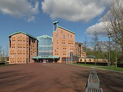
Town hall of Sint-Michielsgestel
|
|||
|
|||
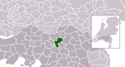
 Location in North Brabant |
|||
| Coordinates: 51°38′N 5°21′E / 51.633°N 5.350°ECoordinates: 51°38′N 5°21′E / 51.633°N 5.350°E | |||
| Country | Netherlands | ||
| Province | North Brabant | ||
| Government | |||
| • Body | Municipal council | ||
| • Mayor | Jan Pommer (CDA) | ||
| Area | |||
| • Total | 59.34 km2 (22.91 sq mi) | ||
| • Land | 58.44 km2 (22.56 sq mi) | ||
| • Water | 0.90 km2 (0.35 sq mi) | ||
| Elevation | 6 m (20 ft) | ||
| Population (May 2014) | |||
| • Total | 28,286 | ||
| • Density | 484/km2 (1,250/sq mi) | ||
| Time zone | CET (UTC+1) | ||
| • Summer (DST) | CEST (UTC+2) | ||
| Postcode | 5258, 5270–5275, 5290–5294 | ||
| Area code | 073 | ||
| Website | sint-michielsgestel |
||
Sint-Michielsgestel (Dutch pronunciation: [ˌsɪntmiˌxilsˈxɛstəl]) is a municipality and a town in the southern part of the Netherlands. It is located directly south of 's-Hertogenbosch, the capital of North Brabant province. Its name refers to archangel St. Michael.
Besselaar, Doornhoek, , Hal, , De Bus, De Hogert, De Loofaart, Heikantse Hoeve, Hersend, Hezelaar, Hoek, Kerkeind, Laar, Maaskantje, , Nijvelaar, Plein, , Ruimel, Tielse Hoeve, Wielsche Hoeven, and Woud.
Major employer in the town of Sint-Michielsgestel is , a resource center for sensory and communicative disabled people formerly known as Institute for the deaf and hearing impaired called aka Viataal.
Most inhabitants are commuters as there is little to no industry in town.
The river Dommel, which flows from a well in Belgium to the river Maas in The Netherlands, divides the town in two parts.
Most of the villagers come here for fishing, since the river is filled with a lot of different fishes. The fish that you will see the most, is the "Driel". The present municipality Sint-Michielsgestel was founded in 1996, by merging Sint-Michielsgestel (est. 1314), Den Dungen (est. 1810) and Berlicum (est. 1238).
The complete village of , which till then partly belonged to Boxtel, was added to Sint-Michielsgestel in 1999.
Archeological finds near the township of Halder indicate that this area was already inhabited during the Roman era. Thousands of Roman coins were found in 1962 not far from the Nieuw Herlaer castle.
These and other local archeological finds are now on display in the Museum of Antiquities at Viataal.
Sint-Michielsgestel was named after the high and dry sandy land (=Gestel) and their catholic church dedicated to archangel St. Michael.
Its name was first mentioned when estates or Herlaer and Gestel were joined in approx. 1314 AD (maybe even earlier but there is no written documentation prior to that time).
The estate of Herlaer already was mentioned in 1142 AD by name as being the estate of Dirck, Monarch of Herlaer.
...
Wikipedia

