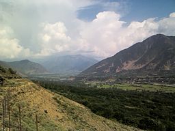
Sind Valley
| Sind Valley | |
| Valley | |
|
The Sind Valley at Wayil
|
|
| Country | India |
|---|---|
| State | Jammu and Kashmir |
| Region | Kashmir Division |
| District | Ganderbal |
| Municipality | Kangan |
| Borders on | Zojila (East) Kashmir Valley (West) |
| River | Sind River |
| Highest point | |
| - location | Baltal |
| - elevation | 9,364 ft (2,854 m) |
| - coordinates | 34°15′22″N 75°25′8″E / 34.25611°N 75.41889°E |
| Lowest point | |
| - location | Wayil |
| - elevation | 5,505 ft (1,678 m) |
| - coordinates | 34°17′21″N 74°48′45″E / 34.28917°N 74.81250°E |
| Length | 40 mi (64 km) |
| Width | 0.6 mi (1 km) |
| Population | 97,874 (2001) |
| Easiest access | NH 1D |
Coordinates: 34°17′21″N 74°48′45″E / 34.28917°N 74.81250°E
The Sind Valley is a Himalayan sub-valley of the Kashmir Valley in the State of Jammu and Kashmir of India. The entrance of the Sind Valley lies 33 kilometres (21 mi) northeast of Srinagar the capital of Jammu and Kashmir. It is a 65 kilometres (40 mi) long gorge valley with an average width of 1 kilometre (0.62 mi).
The Sind Valley had a strategic importance on the ancient Silk Road. It worked as a bridge between India, China and Central Asia along with Srinagar-Skardu Route. First Hinduism and then Islam spread in Kashmir through this route. This route was also taken by a Persian saint Shah Hamdan to enter the Kashmir Valley in 1372 along with his 700 followers (Syeds) who introduced different types of artistic works in the valley. The Sind Valley still connects Ladakh with the rest of India through a National Highway NH 1D, though it remains closed during winter due to heavy snowfall at Zojila.
...
Wikipedia

