Silver bay, Minnesota
| Silver Bay, Minnesota | |
|---|---|
| City | |

Taconite Plant in Silver Bay
|
|
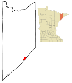
 Location of the city of Silver Bay within Lake County, Minnesota |
|
| Coordinates: 47°17′33″N 91°16′22″W / 47.29250°N 91.27278°W | |
| Country | United States |
| State | Minnesota |
| County | Lake |
| Area | |
| • Total | 8.36 sq mi (21.65 km2) |
| • Land | 7.89 sq mi (20.44 km2) |
| • Water | 0.47 sq mi (1.22 km2) |
| Elevation | 764 ft (233 m) |
| Population (2010) | |
| • Total | 1,887 |
| • Estimate (2012) | 1,867 |
| • Density | 239.2/sq mi (92.4/km2) |
| Time zone | Central (CST) (UTC-6) |
| • Summer (DST) | CDT (UTC-5) |
| ZIP code | 55614 |
| Area code(s) | 218 |
| FIPS code | 27-60250 |
| GNIS feature ID | 0658258 |
| Website | www.silverbay.com |
Silver Bay is a city in Lake County, Minnesota, United States. The population was 1,887 at the 2010 census.
Outer Drive (County Road 5), Penn Boulevard, and Minnesota Highway 61 are three of the main routes in Silver Bay.
According to the United States Census Bureau, the city has a total area of 8.36 square miles (21.65 km2), of which 7.89 square miles (20.44 km2) is land and 0.47 square miles (1.22 km2) is water.
Silver Bay is located 28 miles northeast of the city of Two Harbors.
Tettegouche State Park, the Baptism River, and the Palisade Head rock formation are all nearby.
Summer hiking trails, winter cross country skiing, and maintained snowmobile trails are located within Silver Bay.
The city of Silver Bay was founded on May 1, 1954 after previously being known as the Beaver Bay housing project. The company town was built to process taconite mined and shipped by train from Babbitt, Minnesota, sixty miles to the northwest.
Silver Bay attained widespread publicity in the 1960s when it was discovered that the Reserve Corporation was dumping taconite tailings into Lake Superior. In 1972 they were forced to stop and charged with violating the Rivers and Harbors Act of 1899, which prohibited the dumping of harmful materials into interstate waters. In 1977, after a long trial, a new waste-storage facility was built 7 miles inland.
As of the census of 2010, there were 1,887 people, 836 households, and 542 families residing in the city. The population density was 239.2 inhabitants per square mile (92.4/km2). There were 974 housing units at an average density of 123.4 per square mile (47.6/km2). The racial makeup of the city was 97.9% White, 0.2% African American, 0.3% Native American, 0.3% Asian, 0.3% from other races, and 1.0% from two or more races. Hispanic or Latino of any race were 0.9% of the population.
...
Wikipedia
