Tettegouche State Park
|
Tettegouche Camp Historic District
|
|

Baptism River Falls
|
|
| Location | Off County Hwy. 4, Beaver Bay Township, Lake County, Minnesota |
|---|---|
| Nearest city | Silver Bay, Minnesota |
| Coordinates | 47°20′9″N 91°11′58″W / 47.33583°N 91.19944°WCoordinates: 47°20′9″N 91°11′58″W / 47.33583°N 91.19944°W |
| NRHP Reference # | 88003084 |
| Added to NRHP | January 17, 1989 |
Tettegouche State Park, in the United States, is a Minnesota state park on the north shore of Lake Superior 58 miles (93 km) northeast of Duluth in Lake County on scenic Minnesota Highway 61. The park's name stems from the Tettegouche Club, an association of local businessmen which purchased the park in 1910 from the Alger-Smith Lumber Company. The club's members protected the area until its sale in 1971 to the deLaittres family. In 1979, the state of Minnesota acquired 3,400 acres (1,400 ha) from the Nature Conservancy, including Tettegouche Camp. The land was added to Baptism River State Park, which was renamed Tettegouche State Park.
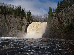
The park is 9,346 acres (3,782 ha), and contains six inland lakes (four of which support northern pike and one supports walleye fishing), four waterfalls, and a beach on Lake Superior. The 70-foot-tall (21 m) waterfall High Falls located on the Baptism River is the highest waterfall located entirely within Minnesota. The park contains 22 miles (35 km) of hiking trails, 12 miles (19 km) of ski trails, and access to the Superior Hiking Trail. Tettegouche is bordered to the north by the Finland State Forest and shares the Red Dot motorized trail with it. The trail is for use by all-terrain vehicles and snowmobiles and is the only ATV trail in a state park.
The park is one of only four state parks in Minnesota offering rock climbing. Both Shovel Point and Palisade Head cliffs are popular spots offering climbing directly over Lake Superior.
...
Wikipedia


