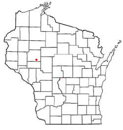
Sigel, Chippewa County, Wisconsin
| Sigel, Wisconsin | |
|---|---|
| Town | |
 Location of Sigel, Wisconsin |
|
| Coordinates: 44°54′9″N 91°10′21″W / 44.90250°N 91.17250°WCoordinates: 44°54′9″N 91°10′21″W / 44.90250°N 91.17250°W | |
| Country | United States |
| State | Wisconsin |
| County | Chippewa |
| Area | |
| • Total | 35.8 sq mi (92.8 km2) |
| • Land | 35.7 sq mi (92.5 km2) |
| • Water | 0.2 sq mi (0.4 km2) |
| Elevation | 961 ft (293 m) |
| Population (2010) | |
| • Total | 1,044 |
| • Density | 29/sq mi (11.3/km2) |
| Time zone | Central (CST) (UTC-6) |
| • Summer (DST) | CDT (UTC-5) |
| Area code(s) | 715 & 534 |
| FIPS code | 55-73875 |
| GNIS feature ID | 1584159 |
| PLSS township | East half of T28N R6W and west half of T28N R7W |
Sigel is a town in Chippewa County in the U.S. state of Wisconsin. The population was 1,044 at the 2010 census, up from 825 at the 2000 census.
The area that became Sigel was first surveyed in the fall of 1848 by crews working for the U.S. government. In September 1849 another crew marked all the section corners of the eastern half of Sigel, walking the woods and swamps on foot, measuring with chain and compass. When done, the deputy surveyor filed this general description:
The Surface in this Township is generally level and a fair proportion good fertile soil. It is well watered by numerous small Streams, none of which, however, afford any water power. A large part of the township is well timbered with Birch, Ash, Elm, Lind, Sugar, Oak, Ironwood and Some Pine.
For a surveyor's description of the six mile square that includes the west half of Sigel, see Lafayette.
The town was founded on January 3, 1863, presumably named after Franz Sigel, a colonel in the Union Army during the American Civil War.
The town of Sigel is located in southern Chippewa County, bordered to the south by Eau Claire County. It is bordered to the north by the Yellow River and the village of Cadott. The Yellow River is a west-flowing tributary of the Chippewa River. According to the United States Census Bureau, Sigel has a total area of 35.8 square miles (92.8 km2), of which 35.7 square miles (92.5 km2) is land and 0.2 square miles (0.4 km2), or 0.38%, is water.
...
Wikipedia
