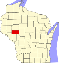
Eau Claire County, Wisconsin
| Eau Claire County, Wisconsin | |
|---|---|

Eau Claire County Courthouse, February 2015
|
|
 Location in the U.S. state of Wisconsin |
|
 Wisconsin's location in the U.S. |
|
| Founded | 1856 |
| Seat | Eau Claire |
| Largest city | Eau Claire |
| Area | |
| • Total | 645 sq mi (1,671 km2) |
| • Land | 638 sq mi (1,652 km2) |
| • Water | 7.3 sq mi (19 km2), 1.1% |
| Population (est.) | |
| • (2014) | 101,564 |
| • Density | 159/sq mi (61/km²) |
| Congressional district | 3rd |
| Time zone | Central: UTC-6/-5 |
| Website | www |
Eau Claire County is a county located in the U.S. state of Wisconsin. As of the 2010 census, the population was 98,736. Its county seat is Eau Claire. The county took its name from the Eau Claire River.
Eau Claire County is included in the Eau Claire, WI Metropolitan Statistical Area as well as the Eau Claire-Menomonie WI Combined Statistical Area.
Eau Claire county was originally set off as the Town of Clearwater in Chippewa County in 1855. The name was changed to the Town of Eau Claire on March 31, 1856. The entire town was separated as Eau Claire County by an act of the Wisconsin State Legislature on October 6, 1856.
According to the U.S. Census Bureau, the county has a total area of 645 square miles (1,670 km2), of which 638 square miles (1,650 km2) is land and 7.3 square miles (19 km2) (1.1%) is water.
As of the census of 2000, there were 93,142 people, 35,822 households, and 22,281 families residing in the county. The population density was 146 inhabitants per square mile (56/km2). There were 37,474 housing units at an average density of 59 per square mile (23/km²). The racial makeup of the county was 94.96% White, 0.52% Black or African American, 0.54% Native American, 2.52% Asian, 0.03% Pacific Islander, 0.33% from other races, and 1.11% from two or more races. 0.94% of the population were Hispanic or Latino of any race. 37.4% were of German, 21.5% Norwegian and 7.0% Irish ancestry according to Census 2000. 94.2% spoke English, 1.6% Hmong, 1.6% Spanish and 1.0% German as their first language.
...
Wikipedia
