Sierra Vista, Arizona
| Sierra Vista, Arizona | |
|---|---|
| City | |
| Nickname(s): Hummingbird Capital of the United States | |
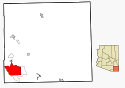
 Location in Cochise County and the state of Arizona |
|
| Location in the United States | |
| Coordinates: 31°32′44″N 110°16′35″W / 31.54556°N 110.27639°WCoordinates: 31°32′44″N 110°16′35″W / 31.54556°N 110.27639°W | |
| Country | United States |
| State | Arizona |
| County | Cochise |
| Incorporated | 1956 |
| Government | |
| • Mayor | Rick Mueller |
| Area | |
| • Total | 152.5 sq mi (395.1 km2) |
| • Land | 152.3 sq mi (394.4 km2) |
| • Water | 0.3 sq mi (0.7 km2) |
| Elevation | 4,633 ft (1,412 m) |
| Population (2010) | |
| • Total | 43,888 |
| • Estimate (2014) | 43,806 |
| • Density | 288/sq mi (111.3/km2) |
| Time zone | MST (no DST) (UTC-7) |
| ZIP codes | 85600-85699 |
| Area code | 520 |
| FIPS code | 04-66820 |
| Website | www |
Sierra Vista is a city in Cochise County, Arizona, United States. As of the 2010 census the population of the city was 43,888. The city is part of the Sierra Vista-Douglas Metropolitan Area, with a 2010 population of 131,346. Fort Huachuca, a U.S. Army post, is located in the northwest part of the city.
Sierra Vista, which is Spanish for "Mountain Range View", is located 75 miles (121 km) southeast of Tucson and serves as the main commercial, cultural, and recreational hub of Cochise County.
At the end of the Apache Wars, with the protection of Fort Huachuca and the completion of the Southern Pacific and El Paso & Southwestern railroads, the San Pedro Valley began to populate. Oliver Fry and his two oldest sons traveled from Texas on the railroad and settled on 320 acres (1.3 km2) just outside Fort Huachuca around 1901.
The first business that opened just outside the east gate of Fort Huachuca was a saloon and house of ill repute owned by John and Ellen Reilly opened in 1892. In 1911, Margaret Carmichael bought the Reilly homestead and business. By 1913, Margaret Carmichael had leased the business back to the Reillys. Also in 1913, a group of dry land farmers settled in the local area and named their settlement Buena. Buena was located east of Garden Canyon on a railroad whistle-stop between Lewis Springs and Fort Huachuca. At this site was a post office and a school house that served children in Buena, Garden Canyon and outreaches of the local area.
By 1917, the Overton Post Office was established. This settlement's name came from the Overton Mercantile and Investment Company, who took option on the Carmichael property with plans to develop a townsite outside of Fort Huachuca. However, it is believed that the company was unable to persuade anyone to move to the area so when the option expired, the Carmichaels took back the property and a general mercantile store.
...
Wikipedia

