Sierra Madre Oriental pine-oak forest
| Sierra Madre Oriental | |
|---|---|

View from an airplane crossing Cerro San Rafael
|
|
| Highest point | |
| Peak | Cerro San Rafael (Coahuila) |
| Elevation | 3,700 m (12,100 ft) |
| Coordinates | 25°22′N 100°33′W / 25.367°N 100.550°WCoordinates: 25°22′N 100°33′W / 25.367°N 100.550°W |
| Geography | |
| Country | Mexico |
| States | |
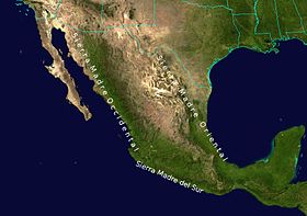
The Sierra Madre Oriental (Spanish ![]() [ˈsjera ˈmaðɾe oɾjenˈtal] ) is a mountain range in northeastern Mexico. The Sierra Madre Oriental is part of the American Cordillera, a chain of mountain ranges (cordillera) that consists of an almost continuous sequence of mountain ranges that form the western "backbone" of North America, Central America, South America and Antarctica.
[ˈsjera ˈmaðɾe oɾjenˈtal] ) is a mountain range in northeastern Mexico. The Sierra Madre Oriental is part of the American Cordillera, a chain of mountain ranges (cordillera) that consists of an almost continuous sequence of mountain ranges that form the western "backbone" of North America, Central America, South America and Antarctica.
Spanning 1,000 kilometres (620 mi) the Sierra Madre Oriental runs from the Rio Grande on the border between Coahuila and Texas south through Nuevo León, southwest Tamaulipas, San Luis Potosí, Querétaro, and Hidalgo to northern Puebla, where it joins with the east-west running Eje Volcánico Transversal of central Mexico. The northernmost are the Sierra del Burro and the Sierra del Carmen which reach the border with the United States at the Rio Grande. North of the Rio Grande, the range continues northwestward into Texas and beyond as the Davis and Guadalupe Ranges.
...
Wikipedia

