Shunan, Yamaguchi
|
Shūnan 周南市 |
||
|---|---|---|
| City | ||

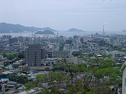
View of downtown Tokuyama area
|
||
|
||
 Location of Shūnan in Yamaguchi Prefecture |
||
| Location in Japan | ||
| Coordinates: 34°3′N 131°48′E / 34.050°N 131.800°ECoordinates: 34°3′N 131°48′E / 34.050°N 131.800°E | ||
| Country | Japan | |
| Region | Chūgoku (San'yō) | |
| Prefecture | Yamaguchi Prefecture | |
| Government | ||
| • Mayor | Kenichiro Kimura (since May 2011) | |
| Area | ||
| • Total | 656.13 km2 (253.33 sq mi) | |
| Population (May 31, 2016) | ||
| • Total | 147,074 | |
| • Density | 224.15/km2 (580.5/sq mi) | |
| Symbols | ||
| • Tree | Cinnamomum camphora | |
| • Flower | Salvia splendens | |
| Time zone | Japan Standard Time (UTC+9) | |
| City hall address | 1-1 Kisan-dōri, Shūnan-shi, Yamaguchi-ken 745-8655 |
|
| Website | www |
|
Shūnan (周南市 Shūnan-shi?) is a city located in east central Yamaguchi Prefecture, Japan.
As of May 31, 2016, the city has an estimated population of 147,074 and a population density of 224.15 persons per km². The total area is 656.13 km².
The modern city of Shūnan was founded on April 21, 2003, by the merger of the cities of Tokuyama and Shinnan'yō, the town of Kumage (from Kumage District), and the town of Kano (from Tsuno District). Its name is derived from the first character (周) of the name of the former Suō Province (周防国), and the character for south (南), reflecting its location, comprising much of the southern part of the old province.
The city is bordered in the west by the cities of Yamaguchi and Hōfu, in the east by Iwakuni, in the southeast by Hikari and Kudamatsu, and in the north by Yoshika, Shimane Prefecture. To the south is the Inland Sea.
...
Wikipedia


