Shorewood, Wisconsin
| Shorewood, Wisconsin | |
|---|---|
| Village | |
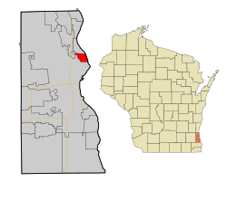
 Location of Shorewood, Wisconsin |
|
| Coordinates: 43°5′31″N 87°53′11″W / 43.09194°N 87.88639°WCoordinates: 43°5′31″N 87°53′11″W / 43.09194°N 87.88639°W | |
| Country | United States |
| State | Wisconsin |
| County | Milwaukee |
| Area | |
| • Total | 1.59 sq mi (4.12 km2) |
| • Land | 1.59 sq mi (4.12 km2) |
| • Water | 0 sq mi (0 km2) |
| Elevation | 679 ft (207 m) |
| Population (2010) | |
| • Total | 13,162 |
| • Estimate (2012) | 13,196 |
| • Density | 8,278.0/sq mi (3,196.2/km2) |
| Time zone | Central (CST) (UTC-6) |
| • Summer (DST) | CDT (UTC-5) |
| Area code(s) | 414 |
| FIPS code | 55-73725 |
| GNIS feature ID | 1574071 |
| Website | villageofshorewood |
Shorewood is a village in Milwaukee County, Wisconsin, United States. The population was 13,162 at the 2010 census. Howell Raines of The New York Times said in 1979 that "[t]his maple-studded town on Lake Michigan dotes on its reputation as Milwaukee's most liberal suburb."
Shorewood is located at 43°05′31″N 87°53′11″W / 43.092061°N 87.886333°W (43.092061, -87.886333).
Nestled between the Milwaukee River and Lake Michigan, Shorewood is bordered by the City of Milwaukee to the south and west and Whitefish Bay to the north. According to the United States Census Bureau, the village has a total area of 1.59 square miles (4.12 km2), all of it land.
Shorewood originally seceded from the Town of Milwaukee in 1900 and was known as East Milwaukee until changing to its present name in 1917.
As of the census of 2010, there were 13,162 people, 6,381 households, and 3,109 families residing in the village. The population density was 8,278.0 inhabitants per square mile (3,196.2/km2). There were 6,750 housing units at an average density of 4,245.3 per square mile (1,639.1/km2). The racial makeup of the village was 88.1% White, 2.9% African American, 0.2% Native American, 5.6% Asian, 0.8% from other races, and 2.3% from two or more races. Hispanic or Latino of any race were 3.4% of the population.
...
Wikipedia
