Shire of Loddon
|
Shire of Loddon Victoria |
|||||||||||||
|---|---|---|---|---|---|---|---|---|---|---|---|---|---|

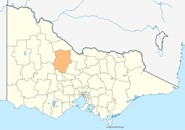
Location in Victoria
|
|||||||||||||
| Population | 7,283 (2015 est) | ||||||||||||
| • Density | 1.08799/km2 (2.8179/sq mi) | ||||||||||||
| Established | 1995 | ||||||||||||
| Gazetted | 19 January 1995 | ||||||||||||
| Area | 6,694 km2 (2,584.6 sq mi) | ||||||||||||
| Mayor | Cr Neil Beattie | ||||||||||||
| Council seat | Wedderburn | ||||||||||||
| Region | Northern Victoria | ||||||||||||
| State electorate(s) | |||||||||||||
| Federal Division(s) | |||||||||||||
 |
|||||||||||||
| Website | Shire of Loddon | ||||||||||||
|
|||||||||||||
The Shire of Loddon is a local government area in Victoria, Australia, located in the northern part of the state. It covers an area of 6,694 square kilometres (2,585 sq mi) and, at the 2011 Census, had a population of 7,459. It includes the towns of Inglewood, Boort, Serpentine, Pyramid Hill and Wedderburn. It was formed in 1995 from the amalgamation of the Shire of East Loddon, Shire of Gordon, Shire of Korong, and parts of the Rural City of Marong, Shire of Bet Bet, Shire of Maldon and Shire of Tullaroop.
The Shire is governed and administered by the Loddon Shire Council; its seat of local government and administrative centre is located at the council headquarters in Wedderburn, it also has service centres located in Boort and Serpentine. The Shire is named after the Loddon River, a major geographical feature that meanders through the LGA.
The council is composed of five wards and five councillors, with one councillor per ward elected to represent each ward.
The council meets in the council chambers at the Serpentine Municipal Offices. It also provides customer services at both its administrative centre in Wedderburn, and its service centres in Boort and Serpentine.
Coordinates: 36°25′06″S 143°52′00″E / 36.41833°S 143.86667°E
...
Wikipedia
