Shire of Gordon
|
Shire of Gordon Victoria |
|||||||||||||||
|---|---|---|---|---|---|---|---|---|---|---|---|---|---|---|---|

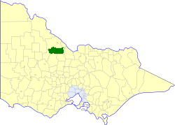
Location in Victoria
|
|||||||||||||||

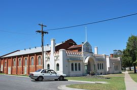
Shire of Gordon memorial hall, Boort
|
|||||||||||||||
| Population | 2,720 (1992) | ||||||||||||||
| • Density | 1.3412/km2 (3.474/sq mi) | ||||||||||||||
| Established | 1885 | ||||||||||||||
| Area | 2,028 km2 (783.0 sq mi) | ||||||||||||||
| Council seat | Boort | ||||||||||||||
| County | Gunbower, Gladstone, Tatchera | ||||||||||||||
|
|||||||||||||||
The Shire of Gordon was a local government area about 245 kilometres (152 mi) north-northwest of Melbourne, the state capital of Victoria, Australia. The shire covered an area of 2,028 square kilometres (783.0 sq mi), and existed from 1885 until 1995.
The Swan Hill Road District, which initially covered most of northwestern Victoria, was incorporated on 8 July 1862, and became a shire on 14 August 1871. The Shire of Gordon was severed and incorporated on 26 May 1885, from parts of the East and West Loddon Ridings, and was named after Major General Charles Gordon. Gordon annexed part of the South West Riding of the Shire of Kerang on 5 October 1977.
On 20 January 1995, the Shire of Gordon was abolished, and, along with the Shires of East Loddon and Korong, and parts of the Rural City of Marong and surrounding districts, was merged into the newly created Shire of Loddon.
The Shire of Gordon was divided into three ridings, each of which elected three councillors:
* Estimate in the 1958 Victorian Year Book.
Coordinates: 36°06′S 143°43′E / 36.100°S 143.717°E
...
Wikipedia
