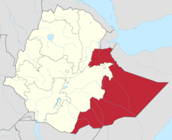
Shinile Zone
|
Sitti Zone Gobolka Sitti |
|
|---|---|

Map of Sitti Zone
|
|
 |
|
| Country | Ethiopia |
| Region | Somali |
| Zone | Sitti |
| Population (2014) | |
| • Total | 546,168 |
| Time zone | EAT (UTC+3) |
Sitti' (Somali: Sitti) Formerly known as Shinile [1] is one of nine Zones of the Somali Region of Ethiopia
Located at the northwestern point of the Somali Region, and stretching across the savanna north of the Ahmar Mountains, Sitti is bordered on the south by Dire Dawa and the Oromia Region, on the west by the Afar Region, on the north by Djibouti, on the east by Somalia, and on the southeast by Jijiga. Other towns and cities in this zone include Aysha, Adi Gala, Shinile, Dewele, Harewa, Adigale, Erer, Bike and Āfdem. Part of the northwestern corner is occupied by the Yangudi Rassa National Park, which is a notable local landmark.
The majority of Issa, now live as agropastoralists. They cultivate sorghum and maize in the south of the zone, in the hilly area at the foot of the highlands, and mainly keep cattle. A total of 15-25% of the inhabitants of the Sitti zone are agropastoralists. This way of life has already entered the Dembel since about 1965. In other areas, cattle breeders started to cultivate agriculture, especially in the early 1990s. They were able to reduce their cattle herds and adapt themselves to the recurring droughts. The transition to Agropastoralism was also promoted by the Ethiopian government. In addition, the Somali wanted to catch up with Oromo peasants from the highlands, who increasingly went to the lowland to cultivate the Somalis land claimed there.
...
Wikipedia
