Shevchenkivskyi District, Dnipropetrovsk
|
Shevchenkivskyi District Шевченківський район |
||
|---|---|---|
| Urban district | ||
|
||
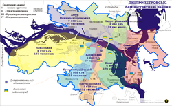
 Map of the urban districts of Dnipropetrovsk. |
||
| Coordinates: 48°31′16″N 34°58′42″E / 48.52111°N 34.97833°ECoordinates: 48°31′16″N 34°58′42″E / 48.52111°N 34.97833°E | ||
| Country |
|
|
| Municipality | Dnipropetrovsk Municipality | |
| Established | 12 April 1973 | |
| Government | ||
| • Chairman of District Council |
Oleh Yurashko | |
| Area | ||
| • Total | 31 km2 (12 sq mi) | |
| Population (2001 census) | ||
| • Total | 159,914 | |
| • Density | 5,200/km2 (13,000/sq mi) | |
| Time zone | EET (UTC+2) | |
| • Summer (DST) | EEST (UTC+3) | |
| Area code | +380 562 | |
| KOATUU | 1210136600 | |
| Website | babushkinskarada |
|
Shevchenkivskyi District (Ukrainian: Шевченківський район) is a right-bank urban district of the city of Dnipropetrovsk, located in southern Ukraine.
It was formed on 12 April 1973 from the territory of Zhovtnevyi, Kirovskyi and Krasnohvardiiskyi districts and was named after Russian Bolshevik revolutionary Ivan Babushkin. On 26 November 2015 the district was renamed by the Dnipropetrovsk city council to its current name to comply with decommunization laws.
Dnipropetrovsk Main Post Office
Dmytro Yavornytsky Avenue in Shevchenkivskyi District
...
Wikipedia

