Sherrodsville, Ohio
| Sherrodsville, Ohio | |
|---|---|
| Village | |

Sherrodsville Community Park in Spring
|
|
 Location of Sherrodsville, Ohio |
|
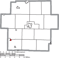
 Location of Sherrodsville in Carroll County |
|
| Coordinates: 40°29′41″N 81°14′40″W / 40.49472°N 81.24444°WCoordinates: 40°29′41″N 81°14′40″W / 40.49472°N 81.24444°W | |
| Country | United States |
| State | Ohio |
| County | Carroll |
| Area | |
| • Total | 0.32 sq mi (0.83 km2) |
| • Land | 0.32 sq mi (0.83 km2) |
| • Water | 0 sq mi (0 km2) |
| Elevation | 909 ft (277 m) |
| Population (2010) | |
| • Total | 304 |
| • Estimate (2012) | 303 |
| • Density | 950.0/sq mi (366.8/km2) |
| Time zone | Eastern (EST) (UTC-5) |
| • Summer (DST) | EDT (UTC-4) |
| ZIP code | 44675 |
| Area code(s) | 740 |
| FIPS code | 39-72242 |
| GNIS feature ID | 1049175 |
Sherrodsville (/ˈʃɛrɒdzvɪl/ SHERR-odz-vil) is a village in Carroll County, Ohio, United States. The population was 304 at the 2010 census. It is part of the Canton–Massillon Metropolitan Statistical Area.
Sherrodsville was laid out in 1882, and named after Charles Sherrod, the original owner of the town site.
Sherrodsville is located on Conotton Creek at 40°29′41″N 81°14′40″W / 40.49472°N 81.24444°W (40.494728, -81.244479).
According to the United States Census Bureau, the village has a total area of 0.32 square miles (0.83 km2), all land.
Sherrodsville is at the intersection of State Routes 39 and 212.
...
Wikipedia
