Sharkey County, MS
| Sharkey County, Mississippi | |
|---|---|

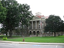
Sharkey County courthouse in Rolling Fork
|
|
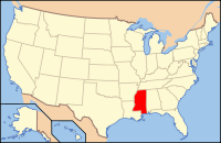
 Location in the U.S. state of Mississippi |
|
 Mississippi's location in the U.S. |
|
| Founded | 1876 |
| Named for | William L. Sharkey |
| Seat | Rolling Fork |
| Largest city | Rolling Fork |
| Area | |
| • Total | 435 sq mi (1,127 km2) |
| • Land | 432 sq mi (1,119 km2) |
| • Water | 3.4 sq mi (9 km2), 0.8% |
| Population | |
| • (2010) | 4,916 |
| • Density | 11/sq mi (4/km2) |
| Congressional district | 2nd |
| Time zone | Central: UTC−6/−5 |
| Website | www |
Sharkey County is a county located in the U.S. state of Mississippi. Part of the western border is formed by the Yazoo River. According to the 2010 census, the population was 4,916, making it the second-least populous county in Mississippi. Its county seat is Rolling Fork. The county is named after William L. Sharkey, the provisional Governor of Mississippi in 1865.
Sharkey County is located in the Mississippi Delta region.
According to the U.S. Census Bureau, the county has a total area of 435 square miles (1,130 km2), of which 432 square miles (1,120 km2) is land and 3.4 square miles (8.8 km2) (0.8%) is water.
As of the 2010 United States Census, there were 4,916 people residing in the county. 71.0% were Black or African American, 27.9% White, 0.2% Asian, 0.1% Native American, 0.4% of some other race and 0.4% or two or more races. 0.8% were Hispanic or Latino (of any race).
As of the census of 2000, there were 6,580 people, 2,163 households, and 1,589 families residing in the county. The population density was 15 people per square mile (6/km²). There were 2,416 housing units at an average density of 6 per square mile (2/km²). The racial makeup of the county was 29.36% White, 69.32% Black or African American, 0.18% Native American, 0.27% Asian, 0.27% from other races, and 0.59% from two or more races. 1.31% of the population were Hispanic or Latino of any race.
...
Wikipedia
