Shamkir District
|
Shamkir Şəmkir |
|
|---|---|
| Rayon | |
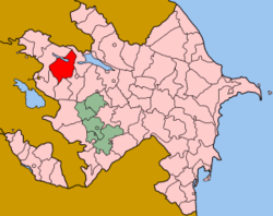
 Map of Azerbaijan showing Shamkir Rayon |
|
| Country |
|
| Shamkhor | 1930 |
| Capital | Şəmkir |
| Government | |
| • executive head | Nazim Veysov |
| Area | |
| • Total | 1,660 km2 (640 sq mi) |
| Population (2010) | |
| • Total | 192,900 |
| Time zone | AZT (UTC+4) |
| • Summer (DST) | AZT (UTC+5) |
| Area code(s) | 241 |
| Website | www.shamkir-ih.gov.az |
Coordinates: 40°49′57″N 46°1′35″E / 40.83250°N 46.02639°E
Shamkir (Azerbaijani: Şəmkir) is a rayon in Azerbaijan. It is located in the northwestern part of the Azerbaijan Republic. The rayon was previously called "Shamkhor" during the Soviet rule and was renamed to Shamkir only in 1991 after restoration of independence of Azerbaijan. The district was established in 1930. The capital of Shamkir Rayon is Shamkir city.
There is one city, Shamkir city, 4 city-type settlements Chinarlı settlement, Dallar settlement, Zayam settlement, Kura settlement and 59 villages in the district. There are 59 large and middle-size, 53 pre-school, 81 secondary education, 1 technical vocational establishments, 22 hospitals and healthcare offices, 156 cultural establishments in the raion.
Shamikir shares a border with Goygol, Gadabay, Dashkasan, Tovuz, Samukh raions.
The population of the district is 192,900 people with 33.49% being urban and 66.51% living in the country. An estimated population density 113.49 person/km2 Men constitute 49.58% of the population, women - 50.42%. Children make up 11.26% of the population, while 33.18% of overall district population are residents below the age of 18, 57.86% are from 18 to 60 years of age. 5.79% have higher education, 56.1% have secondary education only. The number of refugees and IDPs from Nagorno-Karabakh conflict is 12,240 and 1,897, respectively.
...
Wikipedia
